
Dosya:Berlin satellite image with Berlin wall.jpg

Vervênayışê ebadê: 670 × 599 piksel. Agoznayışê bini: 268 × 240 piksel | 537 × 480 piksel | 859 × 768 piksel | 1,145 × 1,024 piksel | 1,506 × 1,347 piksel.
Ebato oricinale (1,506 × 1,347 pikselan, ebatê dosya: 481 KB, MIME tipê cı: image/jpeg)
| Na dosya depoyê Wikimedia Commons de esta u terefê proceyanê binan ra gureniyena. Cêr dê şınasiya dosyay pela mocniyeno. |
Xulasa
| Şınasnayış |
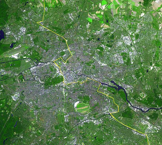
English: Satellite image of Berlin, Germany. The yellow line marks where the Berlin Wall once stood.
This simulated natural color ASTER image covers an area of 22.5 by 20.2 km, and was acquired August 22, 2002. Deutsch: Lage der Berliner Mauer auf einem Satellitenbild,
Gut zu erkennen sind auf diesem Bild aus dem Jahre 2002 die Spree, welche sich horizontal durch die Stadt zieht und der gelb eingezeichnete ehemalige Grenzverlauf zwischen Ost und West. Auffällig sind weiterhin die dichte Bebauung der Berliner Innenstadt innerhalb des S-Bahnrings bzw. der Stadtautobahn, Flughafen Tegel im Nordwesten und Flughafen Tempelhof im Süden, der inmitten der Stadt liegende grüne Tiergarten mit Siegessäule, Messegelände, Tegeler See, Mitte, Spreebogen am Reichstagsgebäude, Lichtenberg, Marzahn und zwei Sportstadien im Osten, Hufeisensiedlung, Britzer Garten südlich des Flughafen Tempelhof...
Español: Situación del Muro de Berlín trazada sobre una fotografía tomada desde un satélite
Slovenčina: Fotografia múru zo satelitu |
|||||
| Tarix | ||||||
| Çıme | http://earthobservatory.nasa.gov/Newsroom/NewImages/images.php3?img_id=16417 | |||||
| Nuştekar |
English: NASA/GSFC/MITI/ERSDAC/JAROS, and U.S./Japan ASTER Science Team |
|||||
| Destur (Reyna sixulnayise ena dosya) |
|

| Annotations | This image is annotated: View the annotations at Commons |
Verêniya dosya
Seba diyayışê viyarteyê dosya ra tarixê ke qısımê tarix/zemani derê inan bıtıkne.
| Tarix/Zeman | Resımo qıckek | Ebadi | Karber | Mışewre | |
|---|---|---|---|---|---|
| nıkayên | 00:53, 20 Nisane 2013 | | 1,506 - 1,347 (481 KB) | Webcyss | Borderline corrected |
| 00:53, 20 Nisane 2013 |  | 1,506 - 1,347 (481 KB) | Webcyss | Borderline corrected | |
| 00:37, 20 Nisane 2013 |  | 1,506 - 1,347 (481 KB) | Webcyss | Borderline corrected | |
| 14:09, 13 Keşkelun 2004 |  | 1,506 - 1,347 (701 KB) | Ed g2s | From http://earthobservatory.nasa.gov/Newsroom/NewImages/images.php3?img_id=16417. {{PD-USGov}} |
Gurenayışê dosya
The following pages link to this file:
Gurenayışê dosyaya gılovere
Ena dosya wikiyanê binan de gureniyena.
- af.wikipedia.org sero guriyayış
- ast.wikipedia.org sero guriyayış
- ba.wikipedia.org sero guriyayış
- bn.wikipedia.org sero guriyayış
- ca.wikipedia.org sero guriyayış
- de.wikipedia.org sero guriyayış
- en.wikipedia.org sero guriyayış
- eo.wikipedia.org sero guriyayış
- es.wikipedia.org sero guriyayış
- fa.wikipedia.org sero guriyayış
- fi.wikipedia.org sero guriyayış
- fr.wikipedia.org sero guriyayış
- gl.wikipedia.org sero guriyayış
- gv.wikipedia.org sero guriyayış
- incubator.wikimedia.org sero guriyayış
- kn.wikipedia.org sero guriyayış
- la.wikipedia.org sero guriyayış
- my.wikipedia.org sero guriyayış
- mzn.wikipedia.org sero guriyayış
- nl.wikipedia.org sero guriyayış
- oc.wikipedia.org sero guriyayış
- pa.wikipedia.org sero guriyayış
- pl.wikipedia.org sero guriyayış
- pt.wikipedia.org sero guriyayış
- ro.wikipedia.org sero guriyayış
- ru.wikipedia.org sero guriyayış
- simple.wikipedia.org sero guriyayış
- si.wikipedia.org sero guriyayış
- sl.wikipedia.org sero guriyayış
- stq.wikipedia.org sero guriyayış
- ta.wikipedia.org sero guriyayış
- tpi.wikipedia.org sero guriyayış
- vi.wikipedia.org sero guriyayış