
Dosya:Brit IndianEmpireReligions3.jpg

Vervênayışê ebadê: 741 × 599 piksel. Agoznayışê bini: 297 × 240 piksel | 593 × 480 piksel | 949 × 768 piksel | 1,266 × 1,024 piksel | 1,534 × 1,241 piksel.
Ebato oricinale (1,534 × 1,241 pikselan, ebatê dosya: 2.33 MB, MIME tipê cı: image/jpeg)
| Na dosya depoyê Wikimedia Commons de esta u terefê proceyanê binan ra gureniyena. Cêr dê şınasiya dosyay pela mocniyeno. |
Xulasa
| Şınasnayış |
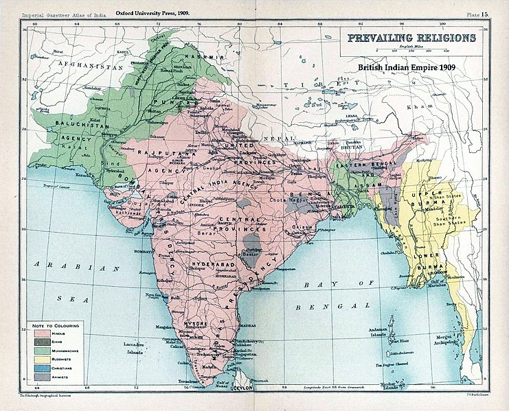
English: Map "Prevailing Religions of the British Indian Empire, 1909" Key:
|
| Tarix | |
| Çıme | The Imperial Gazetteer of India, Oxford University Press, 1909. Scanned from personal copy and annotated by me (Fowler&fowler«Talk» 04:16, 19 March 2007 (UTC)) |
| Nuştekar |
English: John George Bartholomew |
| Versiyonane binan |
.jpg)


|
This old map image could be re-created using vector graphics as an SVG file. This has several advantages; see Commons:Media for cleanup for more information. If an SVG form of this image is available, please upload it and afterwards replace this template with
{{vector version available|new image name}}.
It is recommended to name the SVG file “Brit IndianEmpireReligions3.svg”—then the template Vector version available (or Vva) does not need the new image name parameter. |


Lisans
|
Na gurweynayış DAY dı yana nuskare cı merdışi sera 100 yana dehana veşi zeman reverdo se dewleta piron dı beno Male şariyo. This work is in the public domain in the United States because it was published (or registered with the U.S. Copyright Office) before January 1, 1929. | |
| Na dosya u eleqyın heqê bini heq dê telifiye bındı karkerdışê cı pêro zi miyan hesıbyayê u xoseri lisans deye nışaniyayê. | |
Qeydê barkerdışê oricinali
The original description page was here. All following user names refer to en.wikipedia.
- 2007-03-19 04:16 Fowler&fowler 1650×1275×8 (338398 bytes) Map "Prevailing Religions of the British Indian Empire, 1909" from the Imperial Gazetteer of India, Oxford University Press, 1909. Scanned from personal copy and annotated by me (~~~~) {{PD-old-75}}
| Annotations | This image is annotated: View the annotations at Commons |
Verêniya dosya
Seba diyayışê viyarteyê dosya ra tarixê ke qısımê tarix/zemani derê inan bıtıkne.
| Tarix/Zeman | Resımo qıckek | Ebadi | Karber | Mışewre | |
|---|---|---|---|---|---|
| nıkayên | 02:39, 18 Çele 2019 | | 1,534 - 1,241 (2.33 MB) | Frank Klemm | Cropped, white balanced |
| 13:27, 29 Kanun 2011 |  | 1,504 - 1,232 (2.06 MB) | Maproom | Made colours less washed-out | |
| 01:20, 11 Şıbat 2009 |  | 1,504 - 1,232 (311 KB) | AnonMoos | losslessly cropping margins | |
| 03:06, 21 Keşkelun 2007 |  | 1,650 - 1,275 (330 KB) | Shooke | {{Information |Description=Map "Prevailing Religions of the British Indian Empire, 1909" from the Imperial Gazetteer of India, Oxford University Press, 1909. Scanned from personal copy and annotated by me ([[:en:User:Fowler&fowler|<font color="#B8860B">F |
Gurenayışê dosya
The following pages link to this file:
Gurenayışê dosyaya gılovere
Ena dosya wikiyanê binan de gureniyena.
- af.wikipedia.org sero guriyayış
- ar.wikipedia.org sero guriyayış
- ast.wikipedia.org sero guriyayış
- az.wikipedia.org sero guriyayış
- ba.wikipedia.org sero guriyayış
- bg.wikipedia.org sero guriyayış
- bn.wikipedia.org sero guriyayış
- bn.wikiquote.org sero guriyayış
- ca.wikipedia.org sero guriyayış
- ckb.wikipedia.org sero guriyayış
- cs.wikipedia.org sero guriyayış
- de.wikipedia.org sero guriyayış
- en.wikipedia.org sero guriyayış
- History of India
- Kashmir
- Partition of India
- Gazetteer
- History of Hinduism
- Dominion of India
- British Raj
- User:Fowler&fowler
- Talk:History of Pakistan/History of the Pakistan region
- User:Fowler&fowler/Short History Indian Independence Movement
- User:Fowler&fowler/History of Pakistan
- History of the British Raj
- History of East Pakistan
- Talk:Jammu and Kashmir (state)/Archive 1
- User talk:RegentsPark/Archive 4
- User:Fowler&fowler/History of the Pakistan region
- Talk:British Raj/Archive 8
- User:Falcaorib
- User:Կիմա34/sandbox
- es.wikipedia.org sero guriyayış
- eu.wikipedia.org sero guriyayış
- fa.wikipedia.org sero guriyayış
- fr.wikipedia.org sero guriyayış
Yê na dosya gurenayışê gıloveri tayêna bıvêne.