
Dosya:Geopolitical map of Canada.png

Vervênayışê ebadê: 680 × 599 piksel. Agoznayışê bini: 272 × 240 piksel | 545 × 480 piksel | 872 × 768 piksel | 1,162 × 1,024 piksel | 1,280 × 1,128 piksel.
Ebato oricinale (1,280 × 1,128 pikselan, ebatê dosya: 545 KB, MIME tipê cı: image/png)
| Na dosya depoyê Wikimedia Commons de esta u terefê proceyanê binan ra gureniyena. Cêr dê şınasiya dosyay pela mocniyeno. |
Xulasa
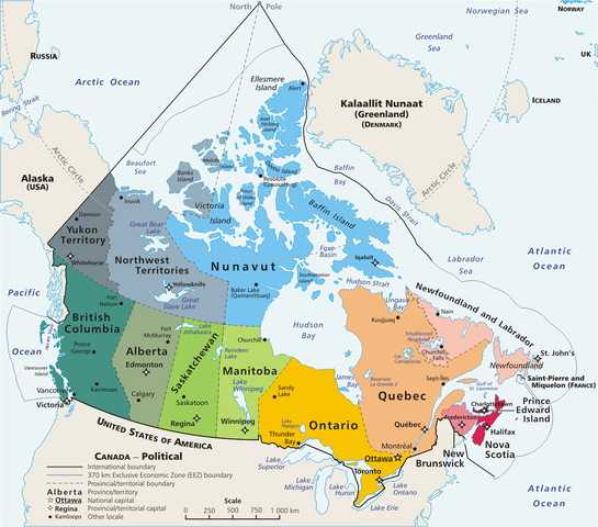
Español: Mapa político de Canadá!, con 10 provincias y 3 territorios.
This is a geopolitical map of Canada, drawn by User:E Pluribus Anthony. Source: en:Image:Map Canada political-geo.png
| Na karkerdış heta nuskar de E Pluribus Anthony at English Wikipediya ra biya malê şari deye hesereyaya. Dınya heme ca dı ravêrena. Tay dewletan dı no kanuniyey heta mıkum nêbone; o haldı: Ez, ena E Pluribus Anthony qande herhangi yew amaci, be şert, hendı ke legali icab nikeni, şari hemi re ezo mısade dana. |
| Annotations | This image is annotated: View the annotations at Commons |
Verêniya dosya
Seba diyayışê viyarteyê dosya ra tarixê ke qısımê tarix/zemani derê inan bıtıkne.
| Tarix/Zeman | Resımo qıckek | Ebadi | Karber | Mışewre | |
|---|---|---|---|---|---|
| nıkayên | 16:32, 5 Gulane 2020 | | 1,280 - 1,128 (545 KB) | Leonel Sohns | Edited |
| 02:18, 10 Nisane 2006 |  | 1,280 - 1,128 (493 KB) | E Pluribus Anthony~commonswiki | Map: Canada – geopolitical | |
| 18:31, 29 Adare 2006 |  | 1,280 - 1,128 (494 KB) | Anchjo | This is a geopolitical map of Canada, drawn by en:User:E Pluribus Anthony. Source: en:Image:Map Canada political-geo.png {{PD-user-wikimedia|E Pluribus Anthony|en}} Category:Maps of Canada |
Gurenayışê dosya
The following pages link to this file:
Gurenayışê dosyaya gılovere
Ena dosya wikiyanê binan de gureniyena.
- ast.wikipedia.org sero guriyayış
- cs.wikipedia.org sero guriyayış
- de.wikipedia.org sero guriyayış
- en.wikipedia.org sero guriyayış
- eo.wikipedia.org sero guriyayış
- es.wikipedia.org sero guriyayış
- fr.wikipedia.org sero guriyayış
- gl.wikipedia.org sero guriyayış
- it.wikipedia.org sero guriyayış
- ko.wikipedia.org sero guriyayış
- lfn.wikipedia.org sero guriyayış
- mt.wikipedia.org sero guriyayış
- mzn.wikipedia.org sero guriyayış
- pl.wikipedia.org sero guriyayış
- sw.wikipedia.org sero guriyayış