
Dosya:Kayseri districts.png

Vervênayışê ebadê: 729 × 600 piksel. Agoznayışê bini: 292 × 240 piksel | 583 × 480 piksel | 999 × 822 piksel.
Ebato oricinale (999 × 822 pikselan, ebatê dosya: 51 KB, MIME tipê cı: image/png)
| Na dosya depoyê Wikimedia Commons de esta u terefê proceyanê binan ra gureniyena. Cêr dê şınasiya dosyay pela mocniyeno. |
Xulasa
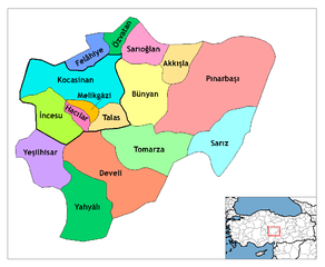
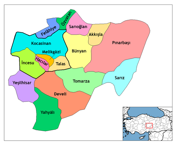
| Şınasnayış | Map of the districts of Kayseri province in Turkey. Created by Rarelibra 21:59, 1 December 2006 (UTC) for public domain use, using MapInfo Professional v8.5 and various mapping resources. Edited by One Homo Sapiens Corrected text where İ, Ş, ı, ğ, or ş occurs in name. Source: [statoids-com]. Increased font size and enhanced color differences among adjacent districts. User:Sae1962 Marked the boundaries of the provincial centre, the city of Kayseri, with bold lines. |
| Tarix | 1 Kanun 2006 (original upload date) |
| Çıme | No machine-readable source provided. Own work assumed (based on copyright claims). |
| Nuştekar | No machine-readable author provided. Rarelibra assumed (based on copyright claims). |
Lisans
| Ez, Wêrê ena teliferê, nê kari Malê şarideye ezo heserena. Dınya heme ca dı ravêreno. Tay dewletan dı no kanuniyey heta mıkum nêbone; o haldı: Ez, ena karer qande herhangi yew amaci, be şert, hendı ke legali icab nikeni, şari hemi re ezo mısade dana. |
Verêniya dosya
Seba diyayışê viyarteyê dosya ra tarixê ke qısımê tarix/zemani derê inan bıtıkne.
| Tarix/Zeman | Resımo qıckek | Ebadi | Karber | Mışewre | |
|---|---|---|---|---|---|
| nıkayên | 11:25, 30 Temuze 2009 | | 999 - 822 (51 KB) | Sae1962 | {{Information |Description=Map of the districts of Kayseri province in Turkey. Created by Rarelibra 21:59, 1 December 2006 (UTC) for public domain use, using MapInfo Professional v8.5 and various mapping resources. Edited by [[User:One |
| 08:24, 4 Gulane 2009 |  | 999 - 822 (50 KB) | Sae1962 | Added long vowels for better reading. | |
| 23:54, 28 Kanun 2008 |  | 1,056 - 816 (35 KB) | One Homo Sapiens | Corrected text where İ,Ş,ı,ğ,or ş occurs in name. Source: [statoids-com]. Increased font size and enhanced color differences among adjacent districts. | |
| 21:59, 1 Kanun 2006 |  | 1,056 - 816 (33 KB) | Rarelibra | Map of the districts of Kayseri province in Turkey. Created by ~~~~ for public domain use, using MapInfo Professional v8.5 and various mapping resources. |
Gurenayışê dosya
The following pages link to this file:
Gurenayışê dosyaya gılovere
Ena dosya wikiyanê binan de gureniyena.
- ast.wikipedia.org sero guriyayış
- az.wikipedia.org sero guriyayış
- be.wikipedia.org sero guriyayış
- ca.wikipedia.org sero guriyayış
- cs.wikipedia.org sero guriyayış
- de.wikipedia.org sero guriyayış
- Kayseri
- Talas (Kayseri)
- Yahyalı
- Hacılar (Kayseri)
- Talas (Bezirk)
- Tomarza
- Wikipedia:Kartenwerkstatt/Archiv/2011-01
- Wikipedia:Kartenwerkstatt/Archiv/2011-05
- Develi (Kayseri)
- Vorlage:Navigationsleiste Landkreise der Provinz Kayseri
- Akkışla
- Bünyan
- Felahiye
- İncesu (Kayseri)
- Kocasinan
- Melikgazi
- Özvatan
- Pınarbaşı (Kayseri)
- Sarıoğlan
- Sarız
- Yeşilhisar (Kayseri)
- en.wikipedia.org sero guriyayış
- en.wiktionary.org sero guriyayış
Yê na dosya gurenayışê gıloveri tayêna bıvêne.