
Dosya:Kosovo map-fr.svg

Ebadê verqaytê PNG na dosyay SVG: 582 × 599 piksel. Agoznayışê bini: 233 × 240 piksel | 466 × 480 piksel | 746 × 768 piksel | 994 × 1,024 piksel | 1,989 × 2,048 piksel | 1,777 × 1,830 piksel.
Ebato oricinale (Dosyay SVGi, nominal 1,777 × 1,830 pikseli, ebadê dosya: 3.75 MB)
| Na dosya depoyê Wikimedia Commons de esta u terefê proceyanê binan ra gureniyena. Cêr dê şınasiya dosyay pela mocniyeno. |
Xulasa
| Şınasnayış |
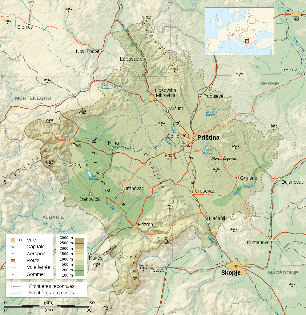
Čeština: Mapa Kosova. Dansk: Kort over Kosovo. Deutsch: Karte des Kosovo. English: Map of the Kosovo. Español: Mapa de Kosovo. Français : Carte du Kosovo. Italiano: Mappa del Kosovo. Magyar: Koszovó térképe albán és szerb helységnevekkel. Polski: Mapa Kosowa. Română: Harta provinciei Kosovo Svenska: Karta över Kosovo, engelskspråkig. Türkçe: Kosova haritası. Русский: Карта Косово, на английском. 日本語: コソボの地図]]。 |
| Tarix | |
| Çıme |
Logiciels utilisés :
Autres données :
|
| Nuştekar | Sémhur |
| Versiyonane binan |
[] |
| Gırêdayış (required by the license) | © Sémhur / Wikimedia Commons / |
| SVG genesis |

| Camera location | | View this and other nearby images on: OpenStreetMap |
|---|
Lisans
Ez, ke ena dosya viraste, bine ena lisansan ser cap kena:
| Copyleft: Ena dosya bedeva ya; ti eşkena ena dosya vila bike ya zi vurne bine Free Art License. Ti eskena sartanê lisansê itiya de Copyleft Attitude site u siteyane binan de bivine. |
This file is licensed under the Creative Commons Attribution-Share Alike 4.0 International, 3.0 Unported, 2.5 Generic, 2.0 Generic and 1.0 Generic license.
- Nê weçenegan dê xoseri:
- bare kerdene – qe gure kopya kerdişi, vila kerdişi u şawitişi
- qe reyna mix kerdişi – qe kabul kerdişi gure
- bine enê şarti:
- gıredayış – Lazımo ke şıma icazet bıdê, lisansi rê link, vuriyayış ke biyo belû kerê. Ney şıma usulên ra şenê bıkerê, labelê karkerdış u iştirakê şıma terefê wayirê lisansi ra zey qebulbiyene yew qeyde çıniyo.
- sey yewbini barekerdış – Meqaleyi ke reyna têv dê, tadê ya zi fına inşa bıkerê, iştırakê şıma lazımo ke zey orcinali same or compatible license bın de vıla kerê.
Ti eskena lisanse xo biwecini.
Verêniya dosya
Seba diyayışê viyarteyê dosya ra tarixê ke qısımê tarix/zemani derê inan bıtıkne.
| Tarix/Zeman | Resımo qıckek | Ebadi | Karber | Mışewre | |
|---|---|---|---|---|---|
| nıkayên | 13:16, 16 Gulane 2008 | | 1,777 - 1,830 (3.75 MB) | Sémhur | Mise en conformité avec les autres cartes de la série (frontières reconnues - frontières litigieuses) |
| 11:13, 4 Adare 2008 |  | 1,777 - 1,830 (3.73 MB) | Sémhur | Neutralisation de la carte par suppression des frontières du Kosovo, textes plus lisibles (plus gros et plus sombres), corrections toponymiques | |
| 22:55, 24 Şıbat 2008 |  | 1,777 - 1,830 (3.73 MB) | Sémhur | {{Information |Description= {{en| French Map of the Kosovo.}} {{fr| Carte du Kosovo.}} |Source=Travail personnel. {{clr}} Sources : * Fond de carte : [http://www2.jpl.nasa.gov/srtm NASA Shuttle Radar Topography Mission] (doma |
Gurenayışê dosya
The following pages link to this file:
Gurenayışê dosyaya gılovere
Ena dosya wikiyanê binan de gureniyena.
- als.wikipedia.org sero guriyayış
- ang.wikipedia.org sero guriyayış
- ast.wikipedia.org sero guriyayış
- azb.wikipedia.org sero guriyayış
- bat-smg.wikipedia.org sero guriyayış
- br.wikipedia.org sero guriyayış
- ca.wikipedia.org sero guriyayış
- el.wikipedia.org sero guriyayış
- eo.wikipedia.org sero guriyayış
- et.wikipedia.org sero guriyayış
- fr.wikipedia.org sero guriyayış
- la.wikipedia.org sero guriyayış
- mk.wikipedia.org sero guriyayış
- no.wikipedia.org sero guriyayış
- sq.wikipedia.org sero guriyayış
- sr.wikipedia.org sero guriyayış