
Dosya:Languages of CE Europe-3.PNG
Vervênayışê ebadê: 524 × 599 piksel. Agoznayışê bini: 210 × 240 piksel | 419 × 480 piksel | 951 × 1,088 piksel.
Ebato oricinale (951 × 1,088 pikselan, ebatê dosya: 769 KB, MIME tipê cı: image/png)
| Na dosya depoyê Wikimedia Commons de esta u terefê proceyanê binan ra gureniyena. Cêr dê şınasiya dosyay pela mocniyeno. |
Xulasa
| Şınasnayış |
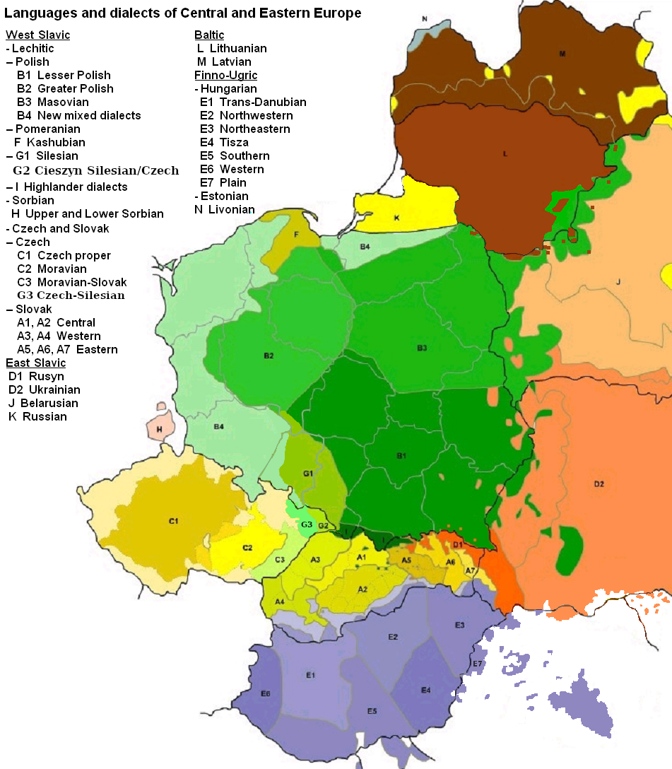
English: Map of languages and dialects of Central and Eastern Europe
Polski: Języki i dialekty Europy Srodkowo-Wschodniej
Deutsch: Legende:
|
||
| Tarix | |||
| Çıme |
Karo şexsi |
||
| Nuştekar | |||
| Versiyonane binan |
|

|
This linguistic map image could be re-created using vector graphics as an SVG file. This has several advantages; see Commons:Media for cleanup for more information. If an SVG form of this image is available, please upload it and afterwards replace this template with
{{vector version available|new image name}}.
It is recommended to name the SVG file “Languages of CE Europe-3.svg”—then the template Vector version available (or Vva) does not need the new image name parameter. |
Lisans

|
Şıma şenê ena dosya kopya kerê, vıla kerê ya zi bıvırnê bınê GNU Free Documentation License, Versiyon 1.2 ya zi versiyonane ke cap biye pê Free Software Foundation; pê nê Invariant Sections, nê Front-Cover Texts u nê Back-Cover Texts. You qısımê kopya bine GNU Free Documentation License estê. |
| Ena dosya binê Creative Commons Attribution-Share Alike 3.0 Unported lisans biya. | ||
| Gırêdayış: Zaragoza, Kpalion, Dellijks | ||
| ||
| Na etiketa lsansi, Dosya dı yew letey GFDL Lisans kerdışi newekerdışi bo deye debiyayo de. |
Qeydê barkerdışê oricinali
This image is a derivative work of the following images:
- File:Languages_of_CE_Europe.PNG licensed with GFDL
- 2008-08-25T20:42:18Z Kpalion 951x1088 (1053557 Bytes) {{Information |Description={{en|Map of languages and dialects of Central and Eastern Europe}} |Source=*[[:Image:Jezyki_i_dialekty_Europa_Srodkowo_Wsch..jpg|]] |Date=2008-08-25 20:40 (UTC) |Author=*derivative work: ~~~ *[[:Ima
Verêniya dosya
Seba diyayışê viyarteyê dosya ra tarixê ke qısımê tarix/zemani derê inan bıtıkne.
| Tarix/Zeman | Resımo qıckek | Ebadi | Karber | Mışewre | |
|---|---|---|---|---|---|
| nıkayên | 06:47, 17 Tebaxe 2019 | | 951 - 1,088 (769 KB) | D T G | G1 - changed western border (compare my other map: File:Gwary śląskie wg Zaręby.png - sources there); G2 - changed name and classification (this was part of the Polish Cieszyn Silesian, after 1920 evolving towards Czech, but it was absurd that it would be classified as Czech when to South-West was just G1, not differentiated from G1 in Poland! I repeat it was absurd!, therefore I created G3, see below); G3 - created Czech-Silesian also know as Lach dialects, up to 1980s regarded by some... |
| 07:42, 17 Tebaxe 2015 |  | 951 - 1,088 (928 KB) | Winnetou14 | Reverted to version as of 19:28, 13 September 2009 | |
| 23:11, 11 Tışrino Peyên 2009 |  | 951 - 1,088 (697 KB) | Alex Tora | {{Information |Description= |Source={{own}} |Date= |Author=Alex Tora |Permission= |other_versions= }} | |
| 19:28, 13 Keşkelun 2009 |  | 951 - 1,088 (928 KB) | Scooter20 | Fixed Hungarian & Ukrainian in Romania, Ukrainian in Moldova and Romanian in Hungary and Ukraine | |
| 22:16, 19 Temuze 2009 |  | 951 - 1,088 (982 KB) | Dellijks | {{Information |Description={{en|Map of languages and dialects of Central and Eastern Europe}}{{pl|Języki i dialekty Europy Srodkowo-Wschodniej}} {{de|-> * B1 - Kleinpolnisch * B2 - Großpolnisch * B3 - Masowisch * B4 - Hochpolnisch * F - Kaschubisch * G1 |
Gurenayışê dosya
The following pages link to this file:
Gurenayışê dosyaya gılovere
Ena dosya wikiyanê binan de gureniyena.
- af.wikipedia.org sero guriyayış
- als.wikipedia.org sero guriyayış
- am.wikipedia.org sero guriyayış
- ang.wikipedia.org sero guriyayış
- an.wikipedia.org sero guriyayış
- arz.wikipedia.org sero guriyayış
- ast.wikipedia.org sero guriyayış
- bo.wikipedia.org sero guriyayış
- br.wikipedia.org sero guriyayış
- csb.wikipedia.org sero guriyayış
- cs.wikipedia.org sero guriyayış
- cv.wikipedia.org sero guriyayış
- da.wikipedia.org sero guriyayış
- de.wikipedia.org sero guriyayış
- el.wikipedia.org sero guriyayış
- en.wikipedia.org sero guriyayış
- en.wiktionary.org sero guriyayış
- eo.wikipedia.org sero guriyayış
- eu.wikipedia.org sero guriyayış
- frr.wikipedia.org sero guriyayış
- fr.wikipedia.org sero guriyayış
- fur.wikipedia.org sero guriyayış
- fy.wikipedia.org sero guriyayış
- gd.wikipedia.org sero guriyayış
- he.wikipedia.org sero guriyayış
- hr.wikipedia.org sero guriyayış
- hsb.wikipedia.org sero guriyayış
- hy.wikipedia.org sero guriyayış
- incubator.wikimedia.org sero guriyayış
- ka.wikipedia.org sero guriyayış
- ko.wikipedia.org sero guriyayış
- la.wikipedia.org sero guriyayış
- mg.wikipedia.org sero guriyayış
- ms.wikipedia.org sero guriyayış
- nl.wikipedia.org sero guriyayış
- pnb.wikipedia.org sero guriyayış
Yê na dosya gurenayışê gıloveri tayêna bıvêne.