
Dosya:New 2000 black percent.gif

Vervênayışê ebadê: 776 × 600 piksel. Agoznayışê bini: 311 × 240 piksel | 621 × 480 piksel | 994 × 768 piksel | 1,280 × 989 piksel | 2,604 × 2,012 piksel.
Ebato oricinale (2,604 × 2,012 pikselan, ebatê dosya: 649 KB, MIME tipê cı: image/gif)
| Na dosya depoyê Wikimedia Commons de esta u terefê proceyanê binan ra gureniyena. Cêr dê şınasiya dosyay pela mocniyeno. |
Xulasa

|
This ethnographic map image could be re-created using vector graphics as an SVG file. This has several advantages; see Commons:Media for cleanup for more information. If an SVG form of this image is available, please upload it and afterwards replace this template with
{{vector version available|new image name}}.
It is recommended to name the SVG file “New 2000 black percent.svg”—then the template Vector version available (or Vva) does not need the new image name parameter. |
| Şınasnayış |
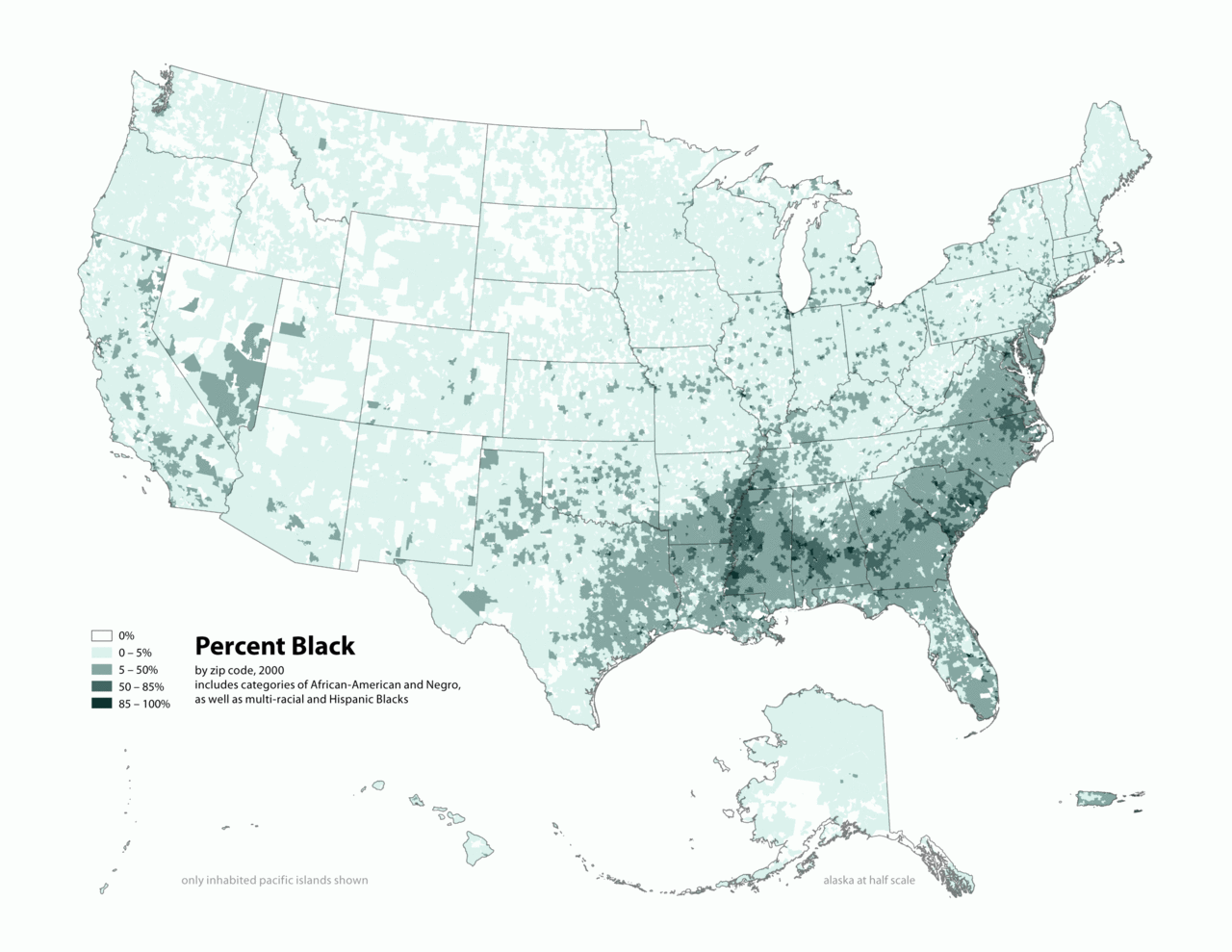
English: Map of contiguous US, showing percentage of population self-reported as "Black," by census tract, 2000. Data source: US Census. |
| Tarix | 3 Nisane 2006 (original upload date) |
| Çıme | Transferred from en.wikipedia to Commons by O'Dea. |
| Nuştekar | The original uploader was Citynoise at English Wikipediya. |
Lisans
Ena dosya binê Creative Commons Attribution-Share Alike 2.5 Generic lisans biya.
- Nê weçenegan dê xoseri:
- bare kerdene – qe gure kopya kerdişi, vila kerdişi u şawitişi
- qe reyna mix kerdişi – qe kabul kerdişi gure
- bine enê şarti:
- gıredayış – Lazımo ke şıma icazet bıdê, lisansi rê link, vuriyayış ke biyo belû kerê. Ney şıma usulên ra şenê bıkerê, labelê karkerdış u iştirakê şıma terefê wayirê lisansi ra zey qebulbiyene yew qeyde çıniyo.
- sey yewbini barekerdış – Meqaleyi ke reyna têv dê, tadê ya zi fına inşa bıkerê, iştırakê şıma lazımo ke zey orcinali same or compatible license bın de vıla kerê.
Qeydê barkerdışê oricinali
The original description page was here. All following user names refer to en.wikipedia.
- 2010-05-01 19:15 Citynoise 2604×2012× (664072 bytes) Added Alaska, Hawaii, and Territories. Also changed from tracts to zip codes.
- 2006-04-03 02:04 Citynoise 1012×691× (78990 bytes) Map of contiguous US, showing percentage of population self-reported as "Black," by census tract, 2000. Data source: US Census. I am the designer and creator of this map and license it under the Creative Commons Attribution ShareAlike 2.5 License. s
Category:Census maps of the United States Category:Maps illustrating African American history Category:African American history
Verêniya dosya
Seba diyayışê viyarteyê dosya ra tarixê ke qısımê tarix/zemani derê inan bıtıkne.
| Tarix/Zeman | Resımo qıckek | Ebadi | Karber | Mışewre | |
|---|---|---|---|---|---|
| nıkayên | 02:48, 31 Kanun 2011 | | 2,604 - 2,012 (649 KB) | Spideog | {{Information |Description={{en|en:Category:Census maps of the United States en:Category:Maps illustrating African American history en:Category:African American history}} |Source=Transferred from [http://en.wikipedia.org en.wikipedia]; t |
Gurenayışê dosya
The following pages link to this file:
Gurenayışê dosyaya gılovere
Ena dosya wikiyanê binan de gureniyena.
- af.wikipedia.org sero guriyayış
- ar.wikipedia.org sero guriyayış
- cs.wikipedia.org sero guriyayış
- de.wikipedia.org sero guriyayış
- en.wikipedia.org sero guriyayış
- fa.wikipedia.org sero guriyayış
- fr.wikipedia.org sero guriyayış
- fy.wikipedia.org sero guriyayış
- he.wikipedia.org sero guriyayış
- ht.wikipedia.org sero guriyayış
- lfn.wikipedia.org sero guriyayış
- pt.wikipedia.org sero guriyayış
- ro.wikipedia.org sero guriyayış
- ru.wikipedia.org sero guriyayış
- test.wikipedia.org sero guriyayış
- tl.wikipedia.org sero guriyayış
- ur.wikipedia.org sero guriyayış
- uz.wikipedia.org sero guriyayış