
Dosya:Pakistan population density.png
Vervênayışê ebadê: 640 × 599 piksel. Agoznayışê bini: 256 × 240 piksel | 820 × 768 piksel | 1,094 × 1,024 piksel | 2,187 × 2,048 piksel | 5,400 × 5,056 piksel.
Ebato oricinale (5,400 × 5,056 pikselan, ebatê dosya: 1.88 MB, MIME tipê cı: image/png)
| Na dosya depoyê Wikimedia Commons de esta u terefê proceyanê binan ra gureniyena. Cêr dê şınasiya dosyay pela mocniyeno. |

|
This file has been superseded by Population Density by Pakistani District - 2017 Census.SVG. It is recommended to use the other file. Please note that deleting superseded images requires consent. Reason to use the other file: "SVG File that uses a better template, is more detailed, and fixes many errors"
|
new file |
Xulasa
| Şınasnayış |
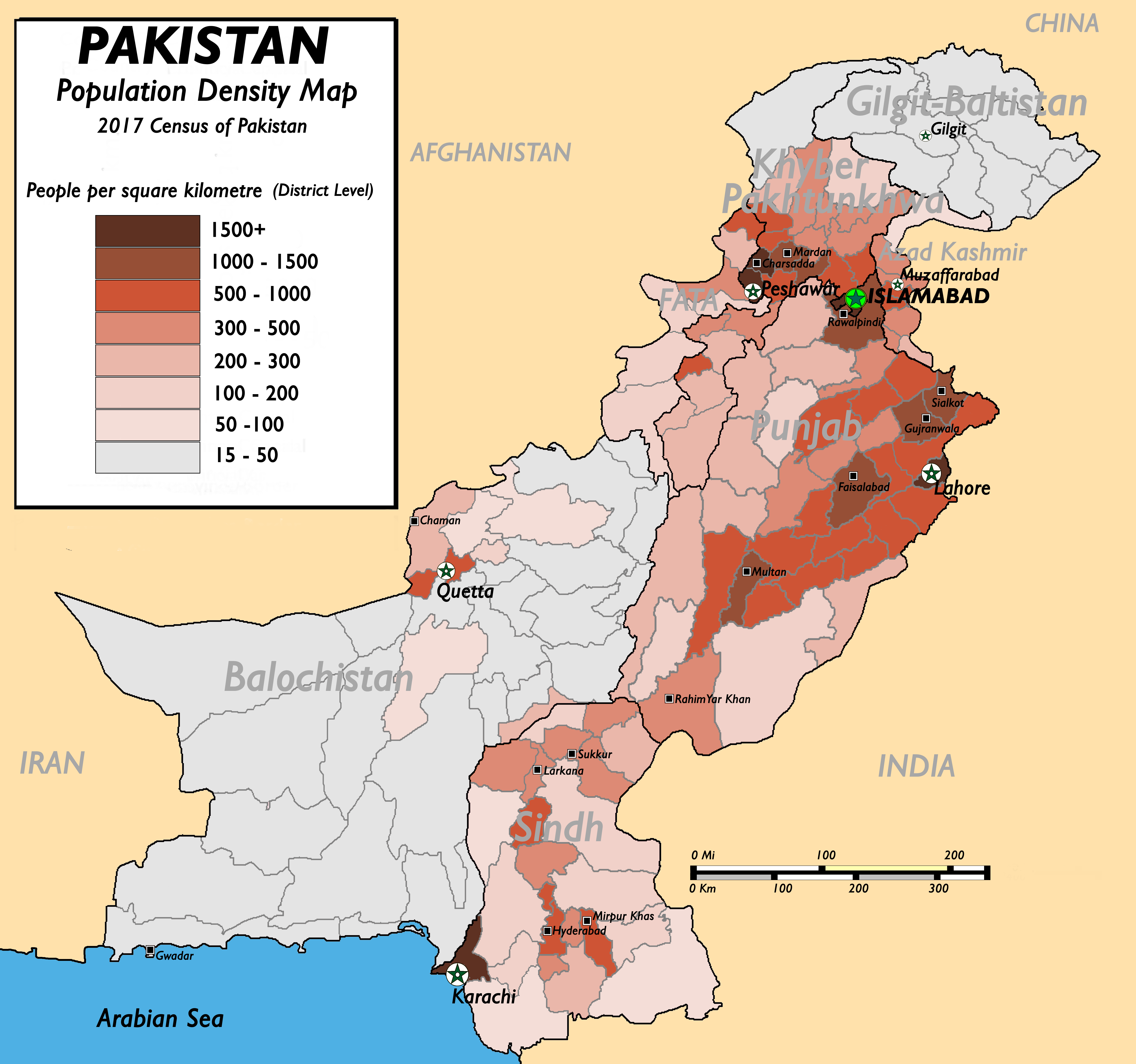
English: Pakistan Population Density Map (English). (Abbreviations used: 1. NWFP = North West Frontier Province, 2. FATA = Federally Administered Tribal Areas.) |
| Tarix | 13 Tebaxe 2009 (original upload date) |
| Çıme |
(New version uploaded by using data from 2017 Pakistan Population Census, Official Website (Original text: I created this work by myself with the sources of World Trade Press and Population census organisation, Government of Pakistan.) |
| Nuştekar | nomi887 (talk) |
Lisans
Nomi887 at English Wikipediya, ke ena dosya viraste, bine ena lisansan ser cap kena:
Ena dosya binê Creative Commons Attribution-Share Alike 3.0 Unported lisans biya.
Gırêdayış: Nomi887 at English Wikipediya
- Nê weçenegan dê xoseri:
- bare kerdene – qe gure kopya kerdişi, vila kerdişi u şawitişi
- qe reyna mix kerdişi – qe kabul kerdişi gure
- bine enê şarti:
- gıredayış – Lazımo ke şıma icazet bıdê, lisansi rê link, vuriyayış ke biyo belû kerê. Ney şıma usulên ra şenê bıkerê, labelê karkerdış u iştirakê şıma terefê wayirê lisansi ra zey qebulbiyene yew qeyde çıniyo.
- sey yewbini barekerdış – Meqaleyi ke reyna têv dê, tadê ya zi fına inşa bıkerê, iştırakê şıma lazımo ke zey orcinali same or compatible license bın de vıla kerê.

|
Şıma şenê ena dosya kopya kerê, vıla kerê ya zi bıvırnê bınê GNU Free Documentation License, Versiyon 1.2 ya zi versiyonane ke cap biye pê Free Software Foundation; pê nê Invariant Sections, nê Front-Cover Texts u nê Back-Cover Texts. You qısımê kopya bine GNU Free Documentation License estê. |
Ti eskena lisanse xo biwecini.
Qeydê barkerdışê oricinali
The original description page was here. All following user names refer to en.wikipedia.
- 2009-08-13 11:22 Brainlara73 1357×1348× (210478 bytes) Reverted to version as of 11:06, 13 August 2009
- 2009-08-13 11:07 Brainlara73 1357×1348× (210478 bytes) location corrected
- 2009-08-13 11:06 Brainlara73 1357×1348× (210478 bytes) location corrected
- 2009-08-13 09:57 Nomi887 1357×1348× (235717 bytes) More scrutinized version.
- 2009-07-07 11:18 Brainlara73 1361×1390× (195660 bytes) Added Jhelum in Punjab
- 2009-06-11 09:46 Nomi887 1361×1390× (212195 bytes) {{Information |Description = Pakistan Population Density Map (English). |Source = I created this work by myself with the sources of [http://www.bestcountryreports.com/Population_Map_Pakistan.html World Trade Press] and [http://www.statpak.gov
Verêniya dosya
Seba diyayışê viyarteyê dosya ra tarixê ke qısımê tarix/zemani derê inan bıtıkne.
| Tarix/Zeman | Resımo qıckek | Ebadi | Karber | Mışewre | |
|---|---|---|---|---|---|
| nıkayên | 12:43, 17 Kanun 2018 | | 5,400 - 5,056 (1.88 MB) | Nomi887 | New version as per Pakistan Population Census of 2017 by using data from #REDIRECTCensus Data, Pakistan Bureau of Statistics |
| 07:57, 11 Nisane 2011 |  | 1,389 - 1,383 (220 KB) | Nomi887 | minor corrections in locations and density | |
| 17:35, 18 Adare 2010 |  | 1,357 - 1,348 (206 KB) | Ranveig | {{Information |Description={{en|Pakistan Population Density Map (English). ''(Abbreviations used: 1. NWFP = North West Frontier Province, 2. FATA = Federally Administered Tribal Areas.)''}} |Source=Transferred from [http://en.wikipedia.org en.wikipedia]<b |
Gurenayışê dosya
The following pages link to this file:
Gurenayışê dosyaya gılovere
Ena dosya wikiyanê binan de gureniyena.
- ba.wikipedia.org sero guriyayış
- bn.wikipedia.org sero guriyayış
- bs.wikipedia.org sero guriyayış
- de.wikipedia.org sero guriyayış
- en.wikipedia.org sero guriyayış
- fr.wikipedia.org sero guriyayış
- fr.wikinews.org sero guriyayış
- hu.wikipedia.org sero guriyayış
- inh.wikipedia.org sero guriyayış
- io.wikipedia.org sero guriyayış
- ja.wikipedia.org sero guriyayış
- mr.wikipedia.org sero guriyayış
- nl.wikipedia.org sero guriyayış
- nl.wikinews.org sero guriyayış
- nn.wikipedia.org sero guriyayış
- no.wikipedia.org sero guriyayış
- pnb.wikipedia.org sero guriyayış
- pt.wikipedia.org sero guriyayış
- ru.wikipedia.org sero guriyayış
- th.wikipedia.org sero guriyayış
- uk.wikipedia.org sero guriyayış
- ur.wikipedia.org sero guriyayış
- vi.wikipedia.org sero guriyayış
- zh.wikipedia.org sero guriyayış