
Dosya:Pont du Gard BLS.jpg

Vervênayışê ebadê: 800 × 309 piksel. Agoznayışê bini: 320 × 124 piksel | 640 × 247 piksel | 1,024 × 395 piksel | 1,280 × 494 piksel | 2,560 × 988 piksel | 12,648 × 4,882 piksel.
Ebato oricinale (12,648 × 4,882 pikselan, ebatê dosya: 18.75 MB, MIME tipê cı: image/jpeg)
| Na dosya depoyê Wikimedia Commons de esta u terefê proceyanê binan ra gureniyena. Cêr dê şınasiya dosyay pela mocniyeno. |
|
Xulasa
| Şınasnayış |
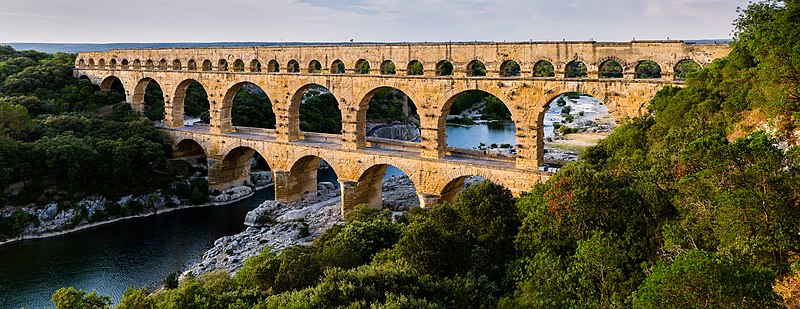
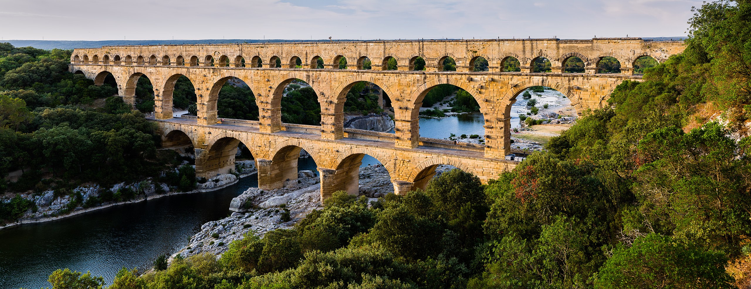
English: Pont du Gard, in Vers-Pont-du-Gard, Gard department, South France. The Pont du Gard is the most famous part of the roman aqueduct which carried water from Uzès to Nîmes until roughly the 9th century when maintenance was abandoned. The monument is 49m high and now 275m long (it was 360m when intact) at its top. It's the highest roman aqueduct, but also one of the best preserved (with the aqueduct of Segovia). The Pont du Gard has been a UNESCO world heritage site since 1985.
Français : Le Pont du Gard, à Vers-Pont-du-Gard, département du Gard, région Languedoc-Roussillon, France. Le Pont du Gard (1er siècle C.E.) est la partie la plus célèbre de l'aqueduc romain qui conduisait l'eau d'Uzès à Nîmes, jusqu'au 9ème siècle où l'on cessa de l'entretenir. Le monument fait 49 mètres de haut et aujourd'hui 275 mètres de long (360 mètres quand il était intact). C'est l'aqueduc roman le plus haut, mais aussi, avec celui de Ségovie, l'un des mieux préservés. Le Pont du Gard est un site du patrimoine mondial de l'humanité de l'UNESCO depuis 1985.
Español: El Pont du Gard (puente del Gard), en Vers-Pont-du-Gard, departamento de Gard, en la región de Languedoc-Rosellón, sur de Francia, es la parte más conocida del acueducto romano que conducía el agua desde Uzès a Nîmes hasta el siglo IX, cuando cesó su actividad. El puente mide 49 metros de alto y 275 metros de largo (360 m cuando se encontraba intacto en la antigüedad). Es el acueducto romano más alto y también, junto al de Segovia, en España, uno de los mejor conservados. El Pont du Gard fue declarado Patrimonio Mundial de la Humanidad por la UNESCO en 1985. |
| Tarix | |
| Çıme | Pont du Gard |
| Nuştekar | Benh LIEU SONG (Flickr) |
| Camera location | | View this and other nearby images on: OpenStreetMap |
|---|
Lisans
Ez, ke ena dosya viraste, bine ena lisans ser cap kena:
Ena dosya binê Creative Commons Attribution-Share Alike 3.0 Unported lisans biya.
- Nê weçenegan dê xoseri:
- bare kerdene – qe gure kopya kerdişi, vila kerdişi u şawitişi
- qe reyna mix kerdişi – qe kabul kerdişi gure
- bine enê şarti:
- gıredayış – Lazımo ke şıma icazet bıdê, lisansi rê link, vuriyayış ke biyo belû kerê. Ney şıma usulên ra şenê bıkerê, labelê karkerdış u iştirakê şıma terefê wayirê lisansi ra zey qebulbiyene yew qeyde çıniyo.
- sey yewbini barekerdış – Meqaleyi ke reyna têv dê, tadê ya zi fına inşa bıkerê, iştırakê şıma lazımo ke zey orcinali same or compatible license bın de vıla kerê.
| Annotations | This image is annotated: View the annotations at Commons |
Verêniya dosya
Seba diyayışê viyarteyê dosya ra tarixê ke qısımê tarix/zemani derê inan bıtıkne.
| Tarix/Zeman | Resımo qıckek | Ebadi | Karber | Mışewre | |
|---|---|---|---|---|---|
| nıkayên | 17:57, 19 Hezirane 2014 | 12,648 - 4,882 (18.75 MB) | Benh | Verticals. | |
| 10:55, 19 Hezirane 2014 | 12,648 - 4,771 (18.78 MB) | Benh | User created page with UploadWizard |
Gurenayışê dosya
The following pages link to this file:
Gurenayışê dosyaya gılovere
Ena dosya wikiyanê binan de gureniyena.
- af.wikipedia.org sero guriyayış
- ar.wikipedia.org sero guriyayış
- ast.wikipedia.org sero guriyayış
- ban.wikipedia.org sero guriyayış
- bg.wikipedia.org sero guriyayış
- bh.wikipedia.org sero guriyayış
- bn.wikipedia.org sero guriyayış
- bn.wikibooks.org sero guriyayış
- bxr.wikipedia.org sero guriyayış
- ca.wikipedia.org sero guriyayış
- ceb.wikipedia.org sero guriyayış
- cs.wikipedia.org sero guriyayış
- cy.wikipedia.org sero guriyayış
- da.wikipedia.org sero guriyayış
- de.wikipedia.org sero guriyayış
- de.wikivoyage.org sero guriyayış
Yê na dosya gurenayışê gıloveri tayêna bıvêne.