
Dosya:SakastanMap.jpg

Vervênayışê ebadê: 733 × 599 piksel. Agoznayışê bini: 294 × 240 piksel | 587 × 480 piksel | 939 × 768 piksel | 1,252 × 1,024 piksel | 1,356 × 1,109 piksel.
Ebato oricinale (1,356 × 1,109 pikselan, ebatê dosya: 258 KB, MIME tipê cı: image/jpeg)
| Na dosya depoyê Wikimedia Commons de esta u terefê proceyanê binan ra gureniyena. Cêr dê şınasiya dosyay pela mocniyeno. |

|
This historical map image could be re-created using vector graphics as an SVG file. This has several advantages; see Commons:Media for cleanup for more information. If an SVG form of this image is available, please upload it and afterwards replace this template with
{{vector version available|new image name}}.
It is recommended to name the SVG file “SakastanMap.svg”—then the template Vector version available (or Vva) does not need the new image name parameter. |


Xulasa
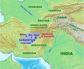
| Şınasnayış | Map of Sakastan circa 100 BCE. Own work. |
| Tarix | 21 Çele 2007 (original upload date) |
| Çıme | No machine-readable source provided. Own work assumed (based on copyright claims). |
| Nuştekar | No machine-readable author provided. World Imaging assumed (based on copyright claims). |
Lisans
| Ez, Wêrê ena teliferê, nê kari Malê şarideye ezo heserena. Dınya heme ca dı ravêreno. Tay dewletan dı no kanuniyey heta mıkum nêbone; o haldı: Ez, ena karer qande herhangi yew amaci, be şert, hendı ke legali icab nikeni, şari hemi re ezo mısade dana. |
Verêniya dosya
Seba diyayışê viyarteyê dosya ra tarixê ke qısımê tarix/zemani derê inan bıtıkne.
| Tarix/Zeman | Resımo qıckek | Ebadi | Karber | Mışewre | |
|---|---|---|---|---|---|
| nıkayên | 21:22, 21 Çele 2007 | | 1,356 - 1,109 (258 KB) | World Imaging | More precise map, with Arachosia. |
| 21:05, 21 Çele 2007 |  | 1,353 - 1,112 (260 KB) | World Imaging | Map of Sakastan circa 100 BCE. Own work. |
Gurenayışê dosya
The following pages link to this file:
Gurenayışê dosyaya gılovere
Ena dosya wikiyanê binan de gureniyena.
- af.wikipedia.org sero guriyayış
- arz.wikipedia.org sero guriyayış
- bcl.wikipedia.org sero guriyayış
- bn.wikipedia.org sero guriyayış
- ca.wikipedia.org sero guriyayış
- cs.wikipedia.org sero guriyayış
- de.wikipedia.org sero guriyayış
- en.wikipedia.org sero guriyayış
- eo.wikipedia.org sero guriyayış
- es.wikipedia.org sero guriyayış
- et.wikipedia.org sero guriyayış
- fa.wikipedia.org sero guriyayış
- hi.wikipedia.org sero guriyayış
- hu.wikipedia.org sero guriyayış
- incubator.wikimedia.org sero guriyayış
- it.wikipedia.org sero guriyayış
- ka.wikipedia.org sero guriyayış
- ku.wikipedia.org sero guriyayış
- ml.wikipedia.org sero guriyayış
- ne.wikipedia.org sero guriyayış
- nl.wikipedia.org sero guriyayış
- pa.wikipedia.org sero guriyayış
- pl.wikipedia.org sero guriyayış
- pl.wiktionary.org sero guriyayış
- ps.wikipedia.org sero guriyayış
- ro.wikipedia.org sero guriyayış
- ru.wikipedia.org sero guriyayış
- sr.wikipedia.org sero guriyayış
- sv.wikipedia.org sero guriyayış
Yê na dosya gurenayışê gıloveri tayêna bıvêne.