
Dosya:Basse Mesopotamie DA.PNG
Deha berz agozney cı çıniyo
Basse_Mesopotamie_DA.PNG (440 × 393 pikselan, ebatê dosya: 158 KB, MIME tipê cı: image/png)
| Na dosya depoyê Wikimedia Commons de esta u terefê proceyanê binan ra gureniyena. Cêr dê şınasiya dosyay pela mocniyeno. |
| Şınasnayış |
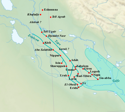
English: Map of the main cities of Lower Mesopotamia during the Early Dynastic period, with the approximate course of the rivers and the ancient shoreline of the Gulf. Français : Carte des principales villes de la Basse Mésopotamie durant la période des Dynasties Archaïques, avec le tracé approximatif des fleuves et l'ancien trait de côte du Golfe. |
| Tarix | (UTC) |
| Çıme | |
| Nuştekar |
|
| no fotraf rotuşin biyo, fotrafi sero hebe ki vırnayış biyo. vırnayışi zi: Ajout du tracé approximatif des fleuves et du trait de côté du Golfe, et de villes..orcinal fotrafo tiya de yo: Near East topographic map-blank.svg. fotrafdı sazbiyayış zi Zunkir kerdo.
|
Ez, ke ena dosya viraste, bine ena lisansan ser cap kena:
Ena dosya binê lisansê Creative Commons Attribution-Share Alike 3.0 Unported, 2.5 Generic, 2.0 Generic and 1.0 Generic lisans biya.
- Nê weçenegan dê xoseri:
- bare kerdene – qe gure kopya kerdişi, vila kerdişi u şawitişi
- qe reyna mix kerdişi – qe kabul kerdişi gure
- bine enê şarti:
- gıredayış – Lazımo ke şıma icazet bıdê, lisansi rê link, vuriyayış ke biyo belû kerê. Ney şıma usulên ra şenê bıkerê, labelê karkerdış u iştirakê şıma terefê wayirê lisansi ra zey qebulbiyene yew qeyde çıniyo.
- sey yewbini barekerdış – Meqaleyi ke reyna têv dê, tadê ya zi fına inşa bıkerê, iştırakê şıma lazımo ke zey orcinali same or compatible license bın de vıla kerê.

|
Şıma şenê ena dosya kopya kerê, vıla kerê ya zi bıvırnê bınê GNU Free Documentation License, Versiyon 1.2 ya zi versiyonane ke cap biye pê Free Software Foundation; pê nê Invariant Sections, nê Front-Cover Texts u nê Back-Cover Texts. You qısımê kopya bine GNU Free Documentation License estê. |
Ti eskena lisanse xo biwecini.
Qeydê barkerdışê oricinali
This image is a derivative work of the following images:
- File:Near_East_topographic_map-blank.svg licensed with Cc-by-sa-3.0,2.5,2.0,1.0, GFDL
- 2009-08-18T18:31:37Z Sémhur 2425x1581 (2442670 Bytes) 3 - New try
- 2009-08-17T15:39:22Z Sémhur 2425x1581 (1815374 Bytes) 2 - With the background...
- 2009-08-17T15:37:36Z Sémhur 2425x1581 (2836 Bytes) {{Information |Description={{en|1=Blank physical map of the [[:en:Near East|Near East]]}} {{fr|1=Carte physique vierge du [[:fr:Proche-Orient|Proche-Orient]].}} |Source={{own}} |Author=[[User:Sémhur|Sémhur]] |Date=2008-08-1
Uploaded with derivativeFX
Verêniya dosya
Seba diyayışê viyarteyê dosya ra tarixê ke qısımê tarix/zemani derê inan bıtıkne.
| Tarix/Zeman | Resımo qıckek | Ebadi | Karber | Mışewre | |
|---|---|---|---|---|---|
| nıkayên | 22:44, 17 Şıbat 2023 | | 440 - 393 (158 KB) | Zunkir | cote et cours d'eau |
| 18:20, 4 Şıbat 2018 |  | 440 - 393 (181 KB) | Zunkir | Tracé des cours d'eau, locations sites. | |
| 12:04, 28 Keşkelun 2010 |  | 1,021 - 730 (817 KB) | Zunkir | {{Information |Description={{en|1=Map of the main cities of Lower Mesopotamia during the Early Dynastic period, with the approximate course of the rivers and the ancient shoreline of the Gulf.}} {{fr|1=Carte des principales villes de la Basse Mésopotamie |
Gurenayışê dosya
The following pages link to this file:
Gurenayışê dosyaya gılovere
Ena dosya wikiyanê binan de gureniyena.
- af.wikipedia.org sero guriyayış
- ar.wikipedia.org sero guriyayış
- arz.wikipedia.org sero guriyayış
- ast.wikipedia.org sero guriyayış
- az.wikipedia.org sero guriyayış
- ba.wikipedia.org sero guriyayış
- be.wikipedia.org sero guriyayış
- ca.wikipedia.org sero guriyayış
- cs.wikipedia.org sero guriyayış
- cy.wikipedia.org sero guriyayış
- de.wikipedia.org sero guriyayış
- en.wikipedia.org sero guriyayış
- eo.wikipedia.org sero guriyayış
- es.wikipedia.org sero guriyayış
- eu.wikipedia.org sero guriyayış
- fa.wikipedia.org sero guriyayış
- fi.wikipedia.org sero guriyayış
- fr.wikipedia.org sero guriyayış
Yê na dosya gurenayışê gıloveri tayêna bıvêne.