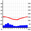
Dosya:Climograma Antártica.png
Climograma_Antártica.png (450 × 450 pikselan, ebatê dosya: 10 KB, MIME tipê cı: image/png)
Verêniya dosya
Seba diyayışê viyarteyê dosya ra tarixê ke qısımê tarix/zemani derê inan bıtıkne.
| Tarix/Zeman | Resımo qıckek | Ebadi | Karber | Mışewre | |
|---|---|---|---|---|---|
| nıkayên | 04:19, 26 Çele 2006 |  | 450 - 450 (10 KB) | B1mbo | Category:Climate diagrams of Chile Climograma de Villa Las Estrellas Ubicación: 62°12'0"S 58°57'51"W Altura: 10 msnm ==Licensing== Climograma basado en el realizado por [http://homeruniverse.nögel.de/Programmieren/Klimadiagramm/Kl |
Gurenayışê dosya
The following pages link to this file:
Gurenayışê dosyaya gılovere
Ena dosya wikiyanê binan de gureniyena.
- az.wikipedia.org sero guriyayış
- crh.wikipedia.org sero guriyayış
- cs.wikipedia.org sero guriyayış
- es.wikipedia.org sero guriyayış
- es.wikivoyage.org sero guriyayış
- fi.wikipedia.org sero guriyayış
- fr.wikipedia.org sero guriyayış
- gl.wikipedia.org sero guriyayış
- hu.wikipedia.org sero guriyayış
- id.wikipedia.org sero guriyayış
- it.wikipedia.org sero guriyayış
- pl.wikipedia.org sero guriyayış
- ru.wikipedia.org sero guriyayış
- uk.wikipedia.org sero guriyayış

