
Dosya:Ingushetia topographic map de.png
Deha berz agozney cı çıniyo
Ingushetia_topographic_map_de.png (263 × 349 pikselan, ebatê dosya: 150 KB, MIME tipê cı: image/png)
| Na dosya depoyê Wikimedia Commons de esta u terefê proceyanê binan ra gureniyena. Cêr dê şınasiya dosyay pela mocniyeno. |
Xulasa
| Şınasnayış |
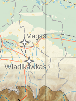
English: Topographic map of Ingushetia.
Deutsch: Topografische Karte Inguschetiens. |
| Tarix | |
| Çıme | Own work by uploader, derivate of File:Georgia topographic map-de.svg |
| Nuştekar | Don-kun |

|
This map image could be re-created using vector graphics as an SVG file. This has several advantages; see Commons:Media for cleanup for more information. If an SVG form of this image is available, please upload it and afterwards replace this template with
{{vector version available|new image name}}.
It is recommended to name the SVG file “Ingushetia topographic map de.svg”—then the template Vector version available (or Vva) does not need the new image name parameter. |
Lisans
Ez, ke ena dosya viraste, bine ena lisansan ser cap kena:
Ena dosya binê Creative Commons Attribution-Share Alike 3.0 Unported lisans biya.
- Nê weçenegan dê xoseri:
- bare kerdene – qe gure kopya kerdişi, vila kerdişi u şawitişi
- qe reyna mix kerdişi – qe kabul kerdişi gure
- bine enê şarti:
- gıredayış – Lazımo ke şıma icazet bıdê, lisansi rê link, vuriyayış ke biyo belû kerê. Ney şıma usulên ra şenê bıkerê, labelê karkerdış u iştirakê şıma terefê wayirê lisansi ra zey qebulbiyene yew qeyde çıniyo.
- sey yewbini barekerdış – Meqaleyi ke reyna têv dê, tadê ya zi fına inşa bıkerê, iştırakê şıma lazımo ke zey orcinali same or compatible license bın de vıla kerê.

|
Şıma şenê ena dosya kopya kerê, vıla kerê ya zi bıvırnê bınê GNU Free Documentation License, Versiyon 1.2 ya zi versiyonane ke cap biye pê Free Software Foundation; pê nê Invariant Sections, nê Front-Cover Texts u nê Back-Cover Texts. You qısımê kopya bine GNU Free Documentation License estê. |
Ti eskena lisanse xo biwecini.
Verêniya dosya
Seba diyayışê viyarteyê dosya ra tarixê ke qısımê tarix/zemani derê inan bıtıkne.
| Tarix/Zeman | Resımo qıckek | Ebadi | Karber | Mışewre | |
|---|---|---|---|---|---|
| nıkayên | 22:30, 8 Nisane 2023 | | 263 - 349 (150 KB) | Merjuev Salovdi | Reverted to version as of 19:50, 13 January 2020 (UTC)richtige Grenzen |
| 05:56, 14 Çele 2020 |  | 1,500 - 1,133 (767 KB) | Don-kun | Reverted to version as of 11:27, 20 February 2014 (UTC) version by Takhirgeran Umar didnt highlight ingushetia, but geogia | |
| 19:50, 13 Çele 2020 |  | 263 - 349 (150 KB) | Takhirgeran Umar | clarification | |
| 11:27, 20 Şıbat 2014 |  | 1,500 - 1,133 (767 KB) | Don-kun | cor Magas | |
| 11:04, 27 Temuze 2009 |  | 1,499 - 1,123 (769 KB) | Don-kun | {{Information |Description={{en|1=Topographic map of Ingushetia. }} {{de|1=Topografische Karte Inguschetiens.}} |Source=Own work by uploader, derivate of File:Georgia topographic map-de.svg |Author=Don-kun |Date=2009-07-27 |Permissio |
Gurenayışê dosya
There are no pages that link to this file.
Gurenayışê dosyaya gılovere
Ena dosya wikiyanê binan de gureniyena.
- azb.wikipedia.org sero guriyayış
- inh.wikipedia.org sero guriyayış
- kbd.wikipedia.org sero guriyayış