
Dosya:Kurdish Areas Sorani.png

Vervênayışê ebadê: 800 × 483 piksel. Agoznayışê bini: 320 × 193 piksel | 640 × 387 piksel | 1,024 × 618 piksel | 1,280 × 773 piksel | 3,000 × 1,812 piksel.
Ebato oricinale (3,000 × 1,812 pikselan, ebatê dosya: 915 KB, MIME tipê cı: image/png)
| Na dosya depoyê Wikimedia Commons de esta u terefê proceyanê binan ra gureniyena. Cêr dê şınasiya dosyay pela mocniyeno. |
Xulasa
| Şınasnayış |
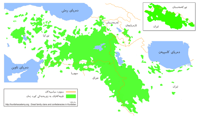
English: Kurdish Areas (Kurdistan). Original source: Kurdish Institute of Paris Map by Mehrdad Izady.
Kurdî: ناوچە کوردنشینەکان (کوردستان)
فارسی: مناطق کردنشین (کردستان) |
| Tarix | |
| Çıme | Karo şexsi |
| Nuştekar | Ferhad y |
Lisans
| Ez, Wêrê ena teliferê, nê kari Malê şarideye ezo heserena. Dınya heme ca dı ravêreno. Tay dewletan dı no kanuniyey heta mıkum nêbone; o haldı: Ez, ena karer qande herhangi yew amaci, be şert, hendı ke legali icab nikeni, şari hemi re ezo mısade dana. |
Verêniya dosya
Seba diyayışê viyarteyê dosya ra tarixê ke qısımê tarix/zemani derê inan bıtıkne.
| Tarix/Zeman | Resımo qıckek | Ebadi | Karber | Mışewre | |
|---|---|---|---|---|---|
| nıkayên | 05:50, 20 Tebaxe 2009 | | 3,000 - 1,812 (915 KB) | Ferhad y | {{Information |Description={{en|1=Kurdish Areas (Kurdistan)}} {{ku|1=ناوچە کوردنشینەکان (کوردستان)}} {{fa|1=مناطق کردنشین (کردستان)}} |Source=Own work by uploader |Author=Ferhad y |Date=2009/08 |
Gurenayışê dosya
The following pages link to this file:
Gurenayışê dosyaya gılovere
Ena dosya wikiyanê binan de gureniyena.
- ckb.wikipedia.org sero guriyayış
- en.wikipedia.org sero guriyayış
- User:KureCewlik81
- User:Hectorian
- User:Vindheim
- User:Ozgurgerilla
- User:WikiMart~enwiki
- User:Soapyyy
- User:Navdar
- User:D.Kurdistani
- User:Makalp
- User talk:Baristarim
- User talk:Bogdangiusca/Archive12
- User:Alanmustafa
- Wikipedia:WikiProject Kurdistan
- Template:User WikiProject Kurdistan
- Wikipedia:WikiProject Kurdistan/Assessment
- User:Asoyrun
- User talk:Aivazovsky/Archive 3
- User:Kermanshahi
- User:Bulgu
- User talk:Biruitorul/Archive2
- User:Bohater
- Wikipedia:WikiProject Kurdistan/Participants
- Wikipedia:WikiProject Kurdistan/Templates
- Wikipedia:WikiProject Kurdistan/User Box
- Template:WPKU-Member
- Template:WPKU-Invite
- Portal:Kurdistan/New articles announcements
- Wikipedia:WikiProject Kurdistan/Outreach
- Wikipedia:WikiProject Kurdistan/Sidebar
- User:Bohater/Userboxes
- Wikipedia:WikiProject Kurdistan/Information/Intro
- Category:Mid-importance Kurdistan articles
- Category:High-importance Kurdistan articles
- Category:Low-importance Kurdistan articles
- Category:Top-importance Kurdistan articles
- User:Sahmeditor/My userboxes
- User:Waterfall999
- User:Nawroz 21 3
- User:Gurgin
- User talk:Chaldean/Archive4
- User:Flavallee
- User:Emadd
- User:Gbeebani
- User:Kurdish Empire
- User:Marmzok
- User:Metino84
- User:Serchia
- User:Rob984
- User:Dewrano
Yê na dosya gurenayışê gıloveri tayêna bıvêne.