
Dosya:Labrador-Peninsula.PNG
Deha berz agozney cı çıniyo
Labrador-Peninsula.PNG (280 × 230 pikselan, ebatê dosya: 14 KB, MIME tipê cı: image/png)
| Na dosya depoyê Wikimedia Commons de esta u terefê proceyanê binan ra gureniyena. Cêr dê şınasiya dosyay pela mocniyeno. |
Xulasa
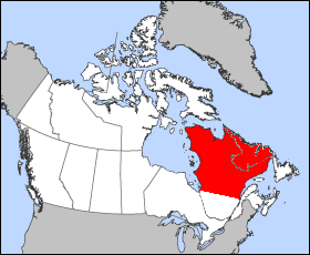
| Şınasnayış | Illustration of the approximate geographic area of the Labrador Peninsula. Modification of "en.wikipedia.org/wiki/Image:Quebec-map.png" |
| Tarix | 25 Kanun 2005 (original upload date) |
| Çıme | No machine-readable source provided. Own work assumed (based on copyright claims). |
| Nuştekar | No machine-readable author provided. Joseph B~commonswiki assumed (based on copyright claims). |
Lisans
| Ez, Wêrê ena teliferê, nê kari Malê şarideye ezo heserena. Dınya heme ca dı ravêreno. Tay dewletan dı no kanuniyey heta mıkum nêbone; o haldı: Ez, ena karer qande herhangi yew amaci, be şert, hendı ke legali icab nikeni, şari hemi re ezo mısade dana. |
Verêniya dosya
Seba diyayışê viyarteyê dosya ra tarixê ke qısımê tarix/zemani derê inan bıtıkne.
| Tarix/Zeman | Resımo qıckek | Ebadi | Karber | Mışewre | |
|---|---|---|---|---|---|
| nıkayên | 20:46, 25 Kanun 2005 | | 280 - 230 (14 KB) | Joseph B~commonswiki | Illustration of the approximate geographic area of the Labrador Peninsula. Modification of "en.wikipedia.org/wiki/Image:Quebec-map.png" |
Gurenayışê dosya
The following pages link to this file:
Gurenayışê dosyaya gılovere
Ena dosya wikiyanê binan de gureniyena.
- ar.wikipedia.org sero guriyayış
- ast.wikipedia.org sero guriyayış
- az.wikipedia.org sero guriyayış
- ba.wikipedia.org sero guriyayış
- bg.wikipedia.org sero guriyayış
- ca.wikipedia.org sero guriyayış
- ceb.wikipedia.org sero guriyayış
- cs.wikipedia.org sero guriyayış
- cy.wikipedia.org sero guriyayış
- da.wikipedia.org sero guriyayış
- de.wikipedia.org sero guriyayış
- de.wiktionary.org sero guriyayış
- el.wikipedia.org sero guriyayış
- en.wikipedia.org sero guriyayış
- eo.wikipedia.org sero guriyayış
- es.wikipedia.org sero guriyayış
- et.wikipedia.org sero guriyayış
- fa.wikipedia.org sero guriyayış
- fi.wikipedia.org sero guriyayış
- fr.wikipedia.org sero guriyayış
- ga.wikipedia.org sero guriyayış
- gl.wikipedia.org sero guriyayış
- he.wikipedia.org sero guriyayış
- hr.wikipedia.org sero guriyayış
- hu.wikipedia.org sero guriyayış
- hy.wikipedia.org sero guriyayış
- it.wikipedia.org sero guriyayış
- ja.wikipedia.org sero guriyayış
- ka.wikipedia.org sero guriyayış
- kk.wikipedia.org sero guriyayış
- ko.wikipedia.org sero guriyayış
- ky.wikipedia.org sero guriyayış
- lt.wikipedia.org sero guriyayış
- mn.wikipedia.org sero guriyayış
- nl.wikipedia.org sero guriyayış
- nn.wikipedia.org sero guriyayış
- no.wikipedia.org sero guriyayış
- pl.wikipedia.org sero guriyayış
- pl.wiktionary.org sero guriyayış
- pt.wikipedia.org sero guriyayış
- ro.wikipedia.org sero guriyayış
- sc.wikipedia.org sero guriyayış
- sh.wikipedia.org sero guriyayış
- sk.wikipedia.org sero guriyayış
- sr.wikipedia.org sero guriyayış
- sv.wikipedia.org sero guriyayış
- ta.wikipedia.org sero guriyayış
Yê na dosya gurenayışê gıloveri tayêna bıvêne.