
Dosya:Madeira 71.jpg

Vervênayışê ebadê: 800 × 447 piksel. Agoznayışê bini: 320 × 179 piksel | 640 × 357 piksel | 1,024 × 572 piksel | 1,280 × 715 piksel | 1,844 × 1,030 piksel.
Ebato oricinale (1,844 × 1,030 pikselan, ebatê dosya: 324 KB, MIME tipê cı: image/jpeg)
| Na dosya depoyê Wikimedia Commons de esta u terefê proceyanê binan ra gureniyena. Cêr dê şınasiya dosyay pela mocniyeno. |
Xulasa
| Şınasnayış |
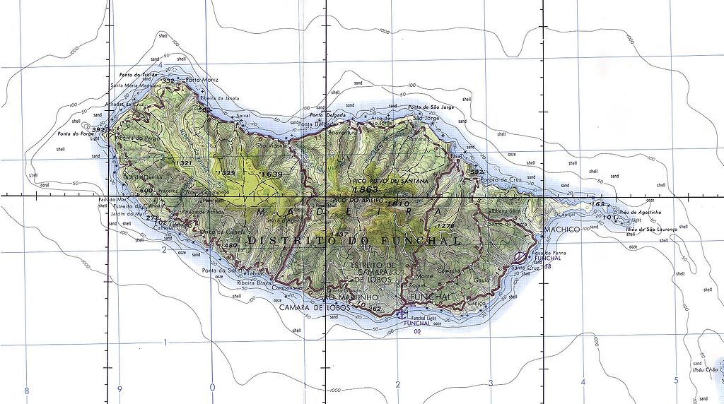
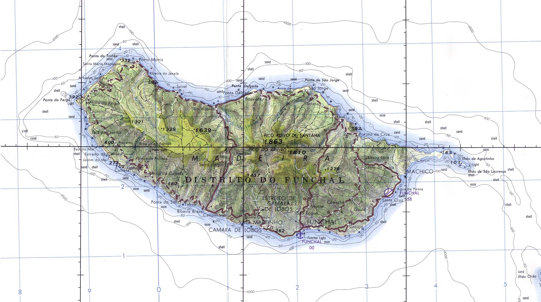
English: Madeira (Portugal) Original scale 1:250,000. Portion of Joint Operations Graphic (Ground) sheet NI 28-13, U.S. Defense Mapping Agency 1976 (325K) Not for navigational use |
| Tarix | |
| Çıme | Madeira (Portugal) (Aeronautical Chart) Original scale 1:250,000. Portion of Joint Operations Graphic (Ground) sheet NI 28-13, U.S. Defense Mapping Agency 1976 from Perry-Castañeda Library Map Collection: Polar Regions and Oceans Maps |
| Nuştekar | U.S. Defense Mapping Agency |
| Destur (Reyna sixulnayise ena dosya) |
Public domain |
Lisans
This image is a work of a U.S. military or Department of Defense employee, taken or made as part of that person's official duties. As a work of the U.S. federal government, the image is in the public domain in the United States.
|
 |
Verêniya dosya
Seba diyayışê viyarteyê dosya ra tarixê ke qısımê tarix/zemani derê inan bıtıkne.
| Tarix/Zeman | Resımo qıckek | Ebadi | Karber | Mışewre | |
|---|---|---|---|---|---|
| nıkayên | 07:30, 8 Şıbat 2005 | | 1,844 - 1,030 (324 KB) | Davenbelle~commonswiki | # Madeira (Portugal) Original scale 1:250,000. Portion of Joint Operations Graphic (Ground) sheet NI 28-13, U.S. Defense Mapping Agency 1976 (325K) Not for navigational use |
Gurenayışê dosya
The following pages link to this file:
Gurenayışê dosyaya gılovere
Ena dosya wikiyanê binan de gureniyena.
- als.wikipedia.org sero guriyayış
- an.wikipedia.org sero guriyayış
- ar.wikipedia.org sero guriyayış
- arz.wikipedia.org sero guriyayış
- ast.wikipedia.org sero guriyayış
- ca.wikipedia.org sero guriyayış
- ce.wikipedia.org sero guriyayış
- cs.wikipedia.org sero guriyayış
- cv.wikipedia.org sero guriyayış
- cy.wikipedia.org sero guriyayış
- de.wikipedia.org sero guriyayış
- en.wikivoyage.org sero guriyayış
- eo.wikipedia.org sero guriyayış
- es.wikipedia.org sero guriyayış
- eu.wikipedia.org sero guriyayış
- fi.wiktionary.org sero guriyayış
- fr.wikipedia.org sero guriyayış
- fr.wikivoyage.org sero guriyayış
- fy.wikipedia.org sero guriyayış
- ga.wikipedia.org sero guriyayış
- gd.wikipedia.org sero guriyayış
- gl.wikipedia.org sero guriyayış
- he.wikipedia.org sero guriyayış
- hu.wikipedia.org sero guriyayış
- hy.wikipedia.org sero guriyayış
- ia.wikipedia.org sero guriyayış
- ig.wikipedia.org sero guriyayış
- lt.wikipedia.org sero guriyayış
- nap.wikipedia.org sero guriyayış
- nds-nl.wikipedia.org sero guriyayış
- nl.wikinews.org sero guriyayış
- nn.wikipedia.org sero guriyayış
- no.wikipedia.org sero guriyayış
- oc.wikipedia.org sero guriyayış
- pl.wikipedia.org sero guriyayış
- ru.wikipedia.org sero guriyayış
- scn.wikipedia.org sero guriyayış
- sr.wikipedia.org sero guriyayış
- stq.wikipedia.org sero guriyayış
- sv.wikipedia.org sero guriyayış
- sw.wikipedia.org sero guriyayış
- tg.wikipedia.org sero guriyayış
- tr.wikipedia.org sero guriyayış
- tt.wikipedia.org sero guriyayış
Yê na dosya gurenayışê gıloveri tayêna bıvêne.