
Dosya:Satellite image of Antigua And Barbuda in September 2002.jpg
Deha berz agozney cı çıniyo
Satellite_image_of_Antigua_And_Barbuda_in_September_2002.jpg (311 × 372 pikselan, ebatê dosya: 16 KB, MIME tipê cı: image/jpeg)
| Na dosya depoyê Wikimedia Commons de esta u terefê proceyanê binan ra gureniyena. Cêr dê şınasiya dosyay pela mocniyeno. |
Xulasa
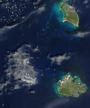
| Şınasnayış | Cropped satellite image, showing the three islands of Antigua And Barbuda. |
| Tarix | |
| Çıme | Cropped from: http://visibleearth.nasa.gov/view_rec.php?id=4342 |
| Nuştekar | Jacques Descloitres, MODIS Rapid Response Team, NASA/GSFC |
Lisans
| This file is in the public domain in the United States because it was solely created by NASA. NASA copyright policy states that "NASA material is not protected by copyright unless noted". (See Template:PD-USGov, NASA copyright policy page or JPL Image Use Policy.) | ||
 |
Warnings:
|
| Annotations | This image is annotated: View the annotations at Commons |
Verêniya dosya
Seba diyayışê viyarteyê dosya ra tarixê ke qısımê tarix/zemani derê inan bıtıkne.
| Tarix/Zeman | Resımo qıckek | Ebadi | Karber | Mışewre | |
|---|---|---|---|---|---|
| nıkayên | 14:26, 18 Kanun 2004 | | 311 - 372 (16 KB) | Hautala | {{PD-USGov-NASA}} Cropped satellite image, showing the three islands of Antigua And Barbuda. Original image taken from NASA's Visible Earth http://visibleearth.nasa.gov/cgi-bin/viewrecord?21888 |
Gurenayışê dosya
The following pages link to this file:
Gurenayışê dosyaya gılovere
Ena dosya wikiyanê binan de gureniyena.
- af.wikipedia.org sero guriyayış
- arz.wikipedia.org sero guriyayış
- ast.wikipedia.org sero guriyayış
- azb.wikipedia.org sero guriyayış
- ca.wikipedia.org sero guriyayış
- cy.wikipedia.org sero guriyayış
- de.wikivoyage.org sero guriyayış
- el.wikipedia.org sero guriyayış
- en.wikipedia.org sero guriyayış
- eo.wikipedia.org sero guriyayış
- fa.wikipedia.org sero guriyayış
- fi.wikipedia.org sero guriyayış
- fr.wikipedia.org sero guriyayış
- ga.wikipedia.org sero guriyayış
- gd.wikipedia.org sero guriyayış
- gl.wikipedia.org sero guriyayış
- ha.wikipedia.org sero guriyayış
- hu.wikipedia.org sero guriyayış
- ia.wikipedia.org sero guriyayış
- io.wikipedia.org sero guriyayış
- ja.wikipedia.org sero guriyayış
- kab.wikipedia.org sero guriyayış
- nl.wikipedia.org sero guriyayış
- pcd.wikipedia.org sero guriyayış
- pl.wikipedia.org sero guriyayış
- pl.wiktionary.org sero guriyayış
- ru.wikipedia.org sero guriyayış
- sq.wikipedia.org sero guriyayış
- uk.wikipedia.org sero guriyayış
- vec.wikipedia.org sero guriyayış
- www.wikidata.org sero guriyayış