
Dosya:The Levant 3.png

Vervênayışê ebadê: 558 × 600 piksel. Agoznayışê bini: 223 × 240 piksel | 447 × 480 piksel | 922 × 991 piksel.
Ebato oricinale (922 × 991 pikselan, ebatê dosya: 290 KB, MIME tipê cı: image/png)
| Na dosya depoyê Wikimedia Commons de esta u terefê proceyanê binan ra gureniyena. Cêr dê şınasiya dosyay pela mocniyeno. |
Xulasa
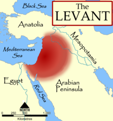
| Şınasnayış | The Levant, based on a NormanEinstein's Image:Fertile Crescent blank base map.png. |
| Tarix | 3 Tışrino Verên 2006 (original upload date) |
| Çıme | No machine-readable source provided. Own work assumed (based on copyright claims). |
| Nuştekar | No machine-readable author provided. MapMaster assumed (based on copyright claims). |
| Versiyonane binan |
[]
|


References
- The American Heritage Dictionary of the English Language, Fourth Edition, Houghton Mifflin Company. "The countries bordering on the eastern Mediterranean Sea from Turkey to Egypt."
- Random House Dictionary, Random House, Inc. 2009. "The lands bordering the E shores of the Mediterranean Sea."
- Harris, William W. (2005) The Levant: a fractured mosaic, Markus Wiener, Second Edition, map p. 4, quote p. 1. "The Mediterranean littoral between the mountains of Cilicia and the Sinai peninsula."
- Oriental Institute, "Levant Site Map", University of Chicago, accessed 15 Dec 2009.
- Council for British Research in the Levant, "The CBRL is the British Academy sponsored society that supports research in the humanities and social sciences in the countries of the Levant: Cyprus, Israel, Jordan, Lebanon, Palestine and Syria, . . .", accessed 15 Dec 2009.
- Biblical and Levantine studies at UCLA, "The ancient cultures of the Levant are defined to include those of western Syria, Lebanon, Israel, Jordan, the Palestinian territories, the Egyptian Sinai, and Cyprus."
Lisans
Ez, ke ena dosya viraste, bine ena lisansan ser cap kena:

|
Şıma şenê ena dosya kopya kerê, vıla kerê ya zi bıvırnê bınê GNU Free Documentation License, Versiyon 1.2 ya zi versiyonane ke cap biye pê Free Software Foundation; pê nê Invariant Sections, nê Front-Cover Texts u nê Back-Cover Texts. You qısımê kopya bine GNU Free Documentation License estê. |
| Ena dosya binê Creative Commons Attribution-Share Alike 3.0 Unported lisans biya. | ||
| ||
| Na etiketa lsansi, Dosya dı yew letey GFDL Lisans kerdışi newekerdışi bo deye debiyayo de. |
Ti eskena lisanse xo biwecini.
derivative works
Derivative works of this file: The Levant-ar.png

|
This locator map image could be re-created using vector graphics as an SVG file. This has several advantages; see Commons:Media for cleanup for more information. If an SVG form of this image is available, please upload it and afterwards replace this template with
{{vector version available|new image name}}.
It is recommended to name the SVG file “The Levant 3.svg”—then the template Vector version available (or Vva) does not need the new image name parameter. |
Verêniya dosya
Seba diyayışê viyarteyê dosya ra tarixê ke qısımê tarix/zemani derê inan bıtıkne.
| Tarix/Zeman | Resımo qıckek | Ebadi | Karber | Mışewre | |
|---|---|---|---|---|---|
| nıkayên | 18:57, 11 Tışrino Verên 2014 | | 922 - 991 (290 KB) | Spiridon Ion Cepleanu | Minor change : diffuse limits |
| 01:32, 4 Tışrino Verên 2006 |  | 922 - 991 (237 KB) | MapMaster | Fixed some problems | |
| 03:54, 3 Tışrino Verên 2006 |  | 922 - 991 (215 KB) | MapMaster | The Levant, based on a NormanEinstein's Image:Fertile Crescent blank base map.png. |
Gurenayışê dosya
The following pages link to this file:
Gurenayışê dosyaya gılovere
Ena dosya wikiyanê binan de gureniyena.
- ast.wikipedia.org sero guriyayış
- az.wikipedia.org sero guriyayış
- ba.wikipedia.org sero guriyayış
- be.wikipedia.org sero guriyayış
- bg.wikipedia.org sero guriyayış
- ca.wikipedia.org sero guriyayış
- ckb.wikipedia.org sero guriyayış
- cs.wikipedia.org sero guriyayış
- cs.wiktionary.org sero guriyayış
- cv.wikipedia.org sero guriyayış
- de.wikipedia.org sero guriyayış
- el.wiktionary.org sero guriyayış
- en.wikipedia.org sero guriyayış
- User:Dimadick
- Coele-Syria
- Talk:Pre-Islamic Arabia
- User:Zdunne
- User:Antoine75
- User:Teemu08
- User:MapMaster
- User:Gwilym84
- User:Zozoulia
- User:Motacilla
- User:James H. Jenkins
- User:Winter queen lizzie
- User:Aus Chia
- User:Imeriki al-Shimoni
- User:L.smithfield
- User:WisamFarouk
- Template:User Levantine History
- User:Jonathan48
- User:Hiram111
- User:Thaum1el/About me
Yê na dosya gurenayışê gıloveri tayêna bıvêne.