
Dosya:Tornesch Friedrichstraße.jpg

Ebato oricinale (1,024 × 640 pikselan, ebatê dosya: 115 KB, MIME tipê cı: image/jpeg)
| Na dosya depoyê Wikimedia Commons de esta u terefê proceyanê binan ra gureniyena. Cêr dê şınasiya dosyay pela mocniyeno. |
Xulasa
| Şınasnayış |
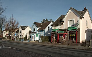
Deutsch: Tornesch (Schleswig-Holstein) - Friedrichstraße 22-28 - Bauzeit: um 1900 und folgende Jahre - Foto 2008 - Die abgebildeten Häuser entstanden alle vor dem Ersten Weltkrieg. Es sind einfache Wohnhäuser mit seitlichem Risalit, die neben den Wohnungen teilweise auch Ladengeschäfte enthalten. Ganz hinten ist das ehemalige "Blumenhaus Sonja" zu sehen (Nr. 28). Vorn sieht man das Chinarestaurant "Jasmin" (Nr. 22). Dort befand sich bis 1967 eine Filiale der Konsumgenossenschaft "Produktion". English: Tornesch (Schleswig-Holstein, Germany), Friedrichstraße 22-28 - construction period: 1900 and following years - photo 2008
- The pictured houses were all created before the First World War. They are simple residential buildings with a side risalit. Some of them contain in addition to the apartments also stores. At the far end is the former "Blumenhaus Sonja" (No. 28). In front you can see the Chinese restaurant "Jasmin" (No. 22). There was until 1967 a branch of the consumer cooperative "Produktion".
|
||||
| Tarix | |||||
| Çıme | Karo şexsi | ||||
| Nuştekar | Uwe Barghaan |
Lisans
- Nê weçenegan dê xoseri:
- bare kerdene – qe gure kopya kerdişi, vila kerdişi u şawitişi
- qe reyna mix kerdişi – qe kabul kerdişi gure
- bine enê şarti:
- gıredayış – Lazımo ke şıma icazet bıdê, lisansi rê link, vuriyayış ke biyo belû kerê. Ney şıma usulên ra şenê bıkerê, labelê karkerdış u iştirakê şıma terefê wayirê lisansi ra zey qebulbiyene yew qeyde çıniyo.
- sey yewbini barekerdış – Meqaleyi ke reyna têv dê, tadê ya zi fına inşa bıkerê, iştırakê şıma lazımo ke zey orcinali same or compatible license bın de vıla kerê.
Verêniya dosya
Seba diyayışê viyarteyê dosya ra tarixê ke qısımê tarix/zemani derê inan bıtıkne.
| Tarix/Zeman | Resımo qıckek | Ebadi | Karber | Mışewre | |
|---|---|---|---|---|---|
| nıkayên | 17:57, 12 Şıbat 2008 | | 1,024 - 640 (115 KB) | Barghaan | {{Information |Description= |Source= |Date= |Author= |Permission= |other_versions= }} |
| 10:58, 6 Şıbat 2008 |  | 1,024 - 768 (100 KB) | Barghaan | {{InformationHof "An der Pinnau" |Description={{de| Tornesch (Schleswig-Holstein), Friedrichstraße , Foto 2008 }} {{en| Tornesch (Slesvic-Holstein, Germany), Friedrichstraße, photo 2008 }} |Source=own work |Date=2008-02-06 |Author=[[:de:Benutzer:Bargh |
Gurenayışê dosya
The following pages link to this file:
Gurenayışê dosyaya gılovere
Ena dosya wikiyanê binan de gureniyena.
- ar.wikipedia.org sero guriyayış
- azb.wikipedia.org sero guriyayış
- ceb.wikipedia.org sero guriyayış
- ce.wikipedia.org sero guriyayış
- da.wikipedia.org sero guriyayış
- de.wikipedia.org sero guriyayış
- es.wikipedia.org sero guriyayış
- eu.wikipedia.org sero guriyayış
- fr.wikipedia.org sero guriyayış
- hu.wikipedia.org sero guriyayış
- it.wikipedia.org sero guriyayış
- ku.wikipedia.org sero guriyayış
- ky.wikipedia.org sero guriyayış
- lld.wikipedia.org sero guriyayış
- pl.wikipedia.org sero guriyayış
- ro.wikipedia.org sero guriyayış
- ru.wikipedia.org sero guriyayış
- sr.wikipedia.org sero guriyayış
- tt.wikipedia.org sero guriyayış
- uz.wikipedia.org sero guriyayış
- vi.wikipedia.org sero guriyayış
- www.wikidata.org sero guriyayış