
Dosya:United Kingdom NUTS location map.svg

Ebadê verqaytê PNG na dosyay SVG: 388 × 600 piksel. Agoznayışê bini: 155 × 240 piksel | 310 × 480 piksel | 497 × 768 piksel | 663 × 1,024 piksel | 1,325 × 2,048 piksel | 886 × 1,369 piksel.
Ebato oricinale (Dosyay SVGi, nominal 886 × 1,369 pikseli, ebadê dosya: 873 KB)
| Na dosya depoyê Wikimedia Commons de esta u terefê proceyanê binan ra gureniyena. Cêr dê şınasiya dosyay pela mocniyeno. |
| Şınasnayış |
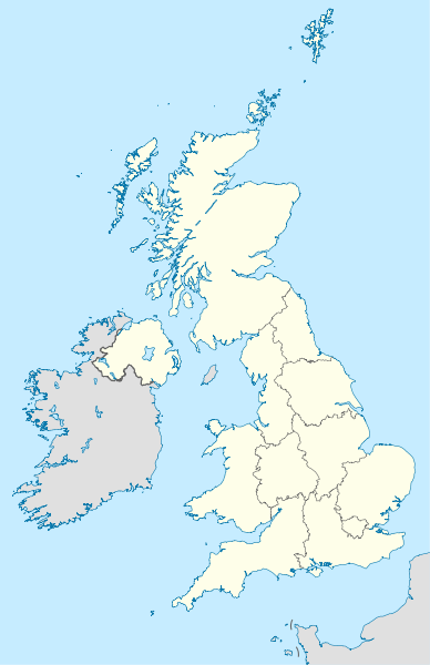
Deutsch: Positionskarte des Vereinigten Königreichs mit NUTS-1-Gebieten
Quadratische Plattkarte, N-S-Streckung 170 %. Geographische Begrenzung der Karte:
English: Location map of the United Kingdom with NUTS 1 areas
Equirectangular projection, N/S stretching 170 %. Geographic limits of the map:
|
| Tarix | (UTC) |
| Çıme | |
| Nuştekar |
|
| Versiyonane binan |
|


Ena dosya binê Creative Commons Attribution-Share Alike 3.0 Unported lisans biya.
- Nê weçenegan dê xoseri:
- bare kerdene – qe gure kopya kerdişi, vila kerdişi u şawitişi
- qe reyna mix kerdişi – qe kabul kerdişi gure
- bine enê şarti:
- gıredayış – Lazımo ke şıma icazet bıdê, lisansi rê link, vuriyayış ke biyo belû kerê. Ney şıma usulên ra şenê bıkerê, labelê karkerdış u iştirakê şıma terefê wayirê lisansi ra zey qebulbiyene yew qeyde çıniyo.
- sey yewbini barekerdış – Meqaleyi ke reyna têv dê, tadê ya zi fına inşa bıkerê, iştırakê şıma lazımo ke zey orcinali same or compatible license bın de vıla kerê.
Qeydê barkerdışê oricinali
This image is a derivative work of the following images:
- File:United_Kingdom_location_map.svg licensed with Cc-by-sa-3.0, GFDL
- 2011-01-11T22:14:29Z NordNordWest 886x1369 (660787 Bytes) upd
- 2008-07-19T21:44:02Z NordNordWest 886x1369 (1484834 Bytes) '
- 2008-07-07T14:29:12Z NordNordWest 886x1369 (1484834 Bytes) '
- 2008-07-01T16:17:52Z NordNordWest 886x1369 (1547699 Bytes) '
- 2008-07-01T16:05:12Z NordNordWest 886x1369 (1546376 Bytes) {{Information |Description= {{de|Positionskarte des [[:de:Vereinigtes Königreich|Vereinigten Königreichs]]}} Quadratische Plattkarte, N-S-Streckung 170 %. Geographische Begrenzung der Karte: * N: 61.0° N * S: 49.0° N * W:
- File:England_location_map.svg licensed with Cc-by-sa-3.0
- 2010-03-12T22:58:19Z Spischot 816x991 (468569 Bytes) {{Information |Description= {{de|Positionskarte von [[:de:England|]]}} Quadratische Plattkarte, N-S-Streckung 170 %. Geographische Begrenzung der Karte: * N: 56.0° N * S: 49.75° N * W: 6.75° W * O: 2.0° O {{en|Location
Uploaded with derivativeFX
Verêniya dosya
Seba diyayışê viyarteyê dosya ra tarixê ke qısımê tarix/zemani derê inan bıtıkne.
| Tarix/Zeman | Resımo qıckek | Ebadi | Karber | Mışewre | |
|---|---|---|---|---|---|
| nıkayên | 14:12, 22 Çele 2011 | | 886 - 1,369 (873 KB) | NordNordWest | {{Information |Description={{de|Positionskarte des Vereinigten Königreichs mit NUTS-1-Gebieten}} Quadratische Plattkarte, N-S-Streckung 170 %. Geographische Begrenzung der Karte: * N: 61.0° N * S: 49.0° N * W: 11.0° |
Gurenayışê dosya
The following pages link to this file:
Gurenayışê dosyaya gılovere
Ena dosya wikiyanê binan de gureniyena.
- als.wikipedia.org sero guriyayış
- ast.wikipedia.org sero guriyayış
- ce.wikipedia.org sero guriyayış
- ckb.wikipedia.org sero guriyayış
- de.wikipedia.org sero guriyayış
- en.wikipedia.org sero guriyayış
- es.wikipedia.org sero guriyayış
- frr.wikipedia.org sero guriyayış
- hy.wikipedia.org sero guriyayış
- io.wikipedia.org sero guriyayış
- kaa.wikipedia.org sero guriyayış
- ka.wikipedia.org sero guriyayış
- kbd.wikipedia.org sero guriyayış
- ky.wikipedia.org sero guriyayış
- lez.wikipedia.org sero guriyayış
- mn.wikipedia.org sero guriyayış
- myv.wikipedia.org sero guriyayış
- nap.wikipedia.org sero guriyayış
- ne.wikipedia.org sero guriyayış
Yê na dosya gurenayışê gıloveri tayêna bıvêne.