
Dosya:Anatolian Plate.png

Vervênayışê ebadê: 800 × 502 piksel. Agoznayışê bini: 320 × 201 piksel | 640 × 402 piksel | 1,024 × 642 piksel | 1,280 × 803 piksel | 2,477 × 1,554 piksel.
Ebato oricinale (2,477 × 1,554 pikselan, ebatê dosya: 2.11 MB, MIME tipê cı: image/png)
| Na dosya depoyê Wikimedia Commons de esta u terefê proceyanê binan ra gureniyena. Cêr dê şınasiya dosyay pela mocniyeno. |
Xulasa
| Şınasnayış |
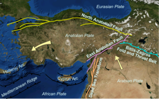
English: Map showing main tectonic structures around the Anatolian Plate on a base taken from a snapshot from Nasa's World Wind software. Arrows show displacement vectors of the Anatolian and Arabian Plates relative to the Eurasian Plate. The locations of the various structures were taken from many published maps. |
| Tarix | |
| Çıme | Karo şexsi |
| Nuştekar | Mikenorton |
Lisans
Ez, ke ena dosya viraste, bine ena lisansan ser cap kena:
Ena dosya binê Creative Commons Attribution-Share Alike 3.0 Unported lisans biya.
- Nê weçenegan dê xoseri:
- bare kerdene – qe gure kopya kerdişi, vila kerdişi u şawitişi
- qe reyna mix kerdişi – qe kabul kerdişi gure
- bine enê şarti:
- gıredayış – Lazımo ke şıma icazet bıdê, lisansi rê link, vuriyayış ke biyo belû kerê. Ney şıma usulên ra şenê bıkerê, labelê karkerdış u iştirakê şıma terefê wayirê lisansi ra zey qebulbiyene yew qeyde çıniyo.
- sey yewbini barekerdış – Meqaleyi ke reyna têv dê, tadê ya zi fına inşa bıkerê, iştırakê şıma lazımo ke zey orcinali same or compatible license bın de vıla kerê.

|
Şıma şenê ena dosya kopya kerê, vıla kerê ya zi bıvırnê bınê GNU Free Documentation License, Versiyon 1.2 ya zi versiyonane ke cap biye pê Free Software Foundation; pê nê Invariant Sections, nê Front-Cover Texts u nê Back-Cover Texts. You qısımê kopya bine GNU Free Documentation License estê. |
Ti eskena lisanse xo biwecini.
Verêniya dosya
Seba diyayışê viyarteyê dosya ra tarixê ke qısımê tarix/zemani derê inan bıtıkne.
| Tarix/Zeman | Resımo qıckek | Ebadi | Karber | Mışewre | |
|---|---|---|---|---|---|
| nıkayên | 22:03, 21 Çele 2011 | | 2,477 - 1,554 (2.11 MB) | Mikenorton | {{Information |Description={{en|1=Map showing main tectonic structures around the Anatolian Plate on a base taken from a snapshot from Nasa's World Wind software. Arrows show displacement vectors of the Anatolian and Arabian Plates relative to the Eurasia |
Gurenayışê dosya
The following pages link to this file:
Gurenayışê dosyaya gılovere
Ena dosya wikiyanê binan de gureniyena.
- az.wikipedia.org sero guriyayış
- ba.wikipedia.org sero guriyayış
- bg.wikipedia.org sero guriyayış
- bs.wikipedia.org sero guriyayış
- ca.wikipedia.org sero guriyayış
- cs.wikipedia.org sero guriyayış
- cy.wikipedia.org sero guriyayış
- de.wikipedia.org sero guriyayış
- de.wikinews.org sero guriyayış
- el.wikipedia.org sero guriyayış
- eo.wikipedia.org sero guriyayış
- es.wikipedia.org sero guriyayış
- eu.wikipedia.org sero guriyayış
- fa.wikipedia.org sero guriyayış
- fi.wikipedia.org sero guriyayış
- fr.wikipedia.org sero guriyayış
- gl.wikipedia.org sero guriyayış
- he.wikipedia.org sero guriyayış
- hi.wikipedia.org sero guriyayış
- hr.wikipedia.org sero guriyayış
- id.wikipedia.org sero guriyayış
- it.wikipedia.org sero guriyayış
Yê na dosya gurenayışê gıloveri tayêna bıvêne.