
Dosya:LA County Incorporated Areas Los Angeles highlighted.svg

Ebadê verqaytê PNG na dosyay SVG: 730 × 599 piksel. Agoznayışê bini: 292 × 240 piksel | 585 × 480 piksel | 935 × 768 piksel | 1,247 × 1,024 piksel | 2,494 × 2,048 piksel | 950 × 780 piksel.
Ebato oricinale (Dosyay SVGi, nominal 950 × 780 pikseli, ebadê dosya: 261 KB)
| Na dosya depoyê Wikimedia Commons de esta u terefê proceyanê binan ra gureniyena. Cêr dê şınasiya dosyay pela mocniyeno. |
Xulasa
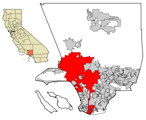
| Şınasnayış | This map shows the incorporated areas in Los Angeles County, California. Los Angeles is highlighted in red. I created it in Inkscape using data from the Los Angeles County Website (Los Angeles County Incorporated Area and District Map (PDF). |
| Tarix | |
| Çıme | My own work, based on public domain information. Though I strove to be as accurate in the detail as possible, the information shown is not guaranteed to be completely accurate. |
| Nuştekar | Ixnayonthetimmay |
| Destur (Reyna sixulnayise ena dosya) |
Public Domain |
| Versiyonane binan | See Category:Maps of Los Angeles County, California for other versions of this image. |
Lisans
| Ez, Wêrê ena teliferê, nê kari Malê şarideye ezo heserena. Dınya heme ca dı ravêreno. Tay dewletan dı no kanuniyey heta mıkum nêbone; o haldı: Ez, ena karer qande herhangi yew amaci, be şert, hendı ke legali icab nikeni, şari hemi re ezo mısade dana. |
Verêniya dosya
Seba diyayışê viyarteyê dosya ra tarixê ke qısımê tarix/zemani derê inan bıtıkne.
| Tarix/Zeman | Resımo qıckek | Ebadi | Karber | Mışewre | |
|---|---|---|---|---|---|
| nıkayên | 07:19, 26 Hezirane 2007 | | 950 - 780 (261 KB) | Ixnayonthetimmay | == Summary == {{Information |Description=This map shows the incorporated areas in Los Angeles County, California. Los Angeles is highlighted in |
Gurenayışê dosya
The following pages link to this file:
Gurenayışê dosyaya gılovere
Ena dosya wikiyanê binan de gureniyena.
- af.wikipedia.org sero guriyayış
- als.wikipedia.org sero guriyayış
- ang.wikipedia.org sero guriyayış
- ar.wikipedia.org sero guriyayış
- arz.wikipedia.org sero guriyayış
- ast.wikipedia.org sero guriyayış
- azb.wikipedia.org sero guriyayış
- bg.wikipedia.org sero guriyayış
- bh.wikipedia.org sero guriyayış
- bn.wikipedia.org sero guriyayış
- ca.wikipedia.org sero guriyayış
- chy.wikipedia.org sero guriyayış
- de.wikipedia.org sero guriyayış
- dty.wikipedia.org sero guriyayış
- el.wikipedia.org sero guriyayış
- en.wikipedia.org sero guriyayış
- Los Angeles
- Los Angeles Police Department
- Harbor Gateway, Los Angeles
- Municipal annexation in the United States
- Category:Neighborhoods in Los Angeles
- National Register of Historic Places listings in Los Angeles
- Killing of Ezell Ford
- Wikipedia talk:WikiProject China/Archive 26
- Talk:New York (state)/Archive 7
- User:Hparham865
- User:Nate.beisheim/sandbox10
- en.wikinews.org sero guriyayış
- es.wikipedia.org sero guriyayış
- eu.wikipedia.org sero guriyayış
- ext.wikipedia.org sero guriyayış
- fa.wikipedia.org sero guriyayış
- fi.wikipedia.org sero guriyayış
- fo.wikipedia.org sero guriyayış
- fr.wikipedia.org sero guriyayış
- Los Angeles
- Projet:Charte graphique/Domaine géographique
- Los Angeles Police Department
- Modèle:Infobox Ville des États-Unis
- Modèle:Infobox Ville des États-Unis/Documentation
- Gangster Squad (LAPD)
- Community Resources Against Street Hoodlums
- Division métropolitaine du Los Angeles Police Department
- Modèle:Infobox Ville des États-Unis/Bac à sable
- fr.wikinews.org sero guriyayış
- fy.wikipedia.org sero guriyayış
- ga.wikipedia.org sero guriyayış
Yê na dosya gurenayışê gıloveri tayêna bıvêne.