
Dosya:La Sacra ammantata dalla neve.jpg
Vervênayışê ebadê: 800 × 373 piksel. Agoznayışê bini: 320 × 149 piksel | 640 × 299 piksel | 1,024 × 478 piksel | 1,280 × 597 piksel | 2,560 × 1,195 piksel | 8,000 × 3,733 piksel.
Ebato oricinale (8,000 × 3,733 pikselan, ebatê dosya: 13.86 MB, MIME tipê cı: image/jpeg)
| Na dosya depoyê Wikimedia Commons de esta u terefê proceyanê binan ra gureniyena. Cêr dê şınasiya dosyay pela mocniyeno. |
Xulasa
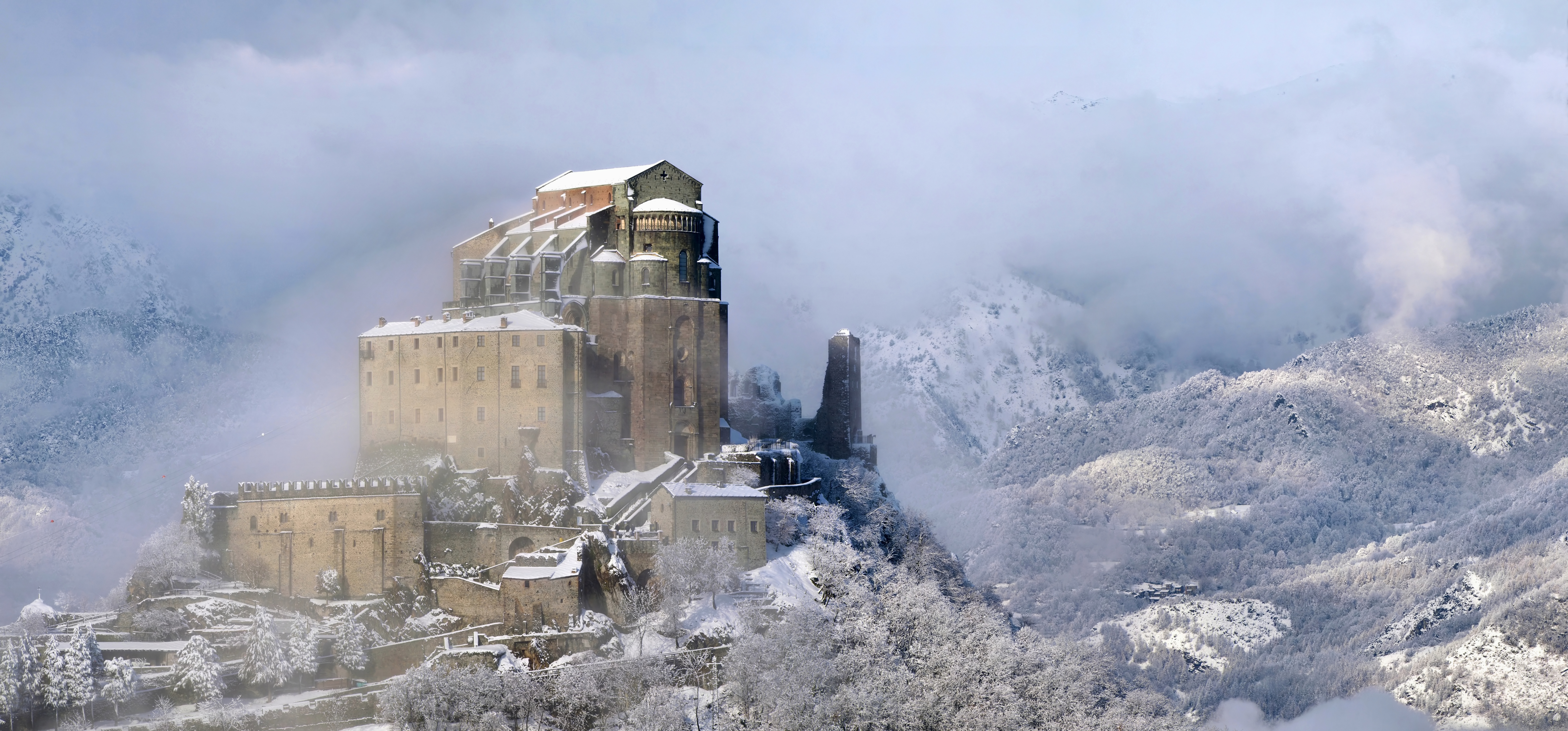
| The Sacred mantled by the snow | |
|---|---|
| Fotrafwan | |
| Sername |
Italian: La Sacra ammantata dalla neve The Sacred mantled by the snow |
| Şınasnayış |
Deutsch: Die Abtei Sacra di San Michele („Heiligtum des heiligen Michael“) auf dem Monte Pirchiriano an der Südseite des Susatals im Piemont (Italien). Die Abtei wurde Ende des 10./Anfang des 11. Jahrhunderts gegründet und befindet sich auf dem Pilgerweg zwischen dem Monte Sant’Angelo in Süditalien und dem Mont-Saint-Michel in Nordfrankreich.
English: The Sacra di San Michele, sometimes known as Saint Michael's Abbey, is an architectural complex built on top of Mount Pirchiriano, situated on the south side of the Susa valley, in the Piedmont region of northern Italy. Founded between the late 10th and the early 11th century, the abbey is located along the pilgrimage route that joins Monte Sant'Angelo, in the south of Italy, to Mont Saint-Michel, in the north of France.
Esperanto: Abatejo de Sankta Mikaelo sur la monto Pirchiriano, Piemonto, Italio.
Español: La Sacra di San Michele (abadía de San Miguel), erigido en la cima del monte Pirchiriano, se encuentra en el sur del valle de Susa, en la región del Piamonte en el norte de Italia. La abadía fue fundada entre finales del siglo X y principios del siglo XI y se encuentra en la ruta de peregrinación que conecta Monte Sant'Angelo, en el sur de Italia, con Mont Saint-Michel, en el norte de Francia.
Français : Abbaye Saint-Michel-de-la-Cluse sur le mont Pirchiriano, Piémont, Italie.
Italiano: La sacra di San Michele è un complesso architettonico collocato sul monte Pirchiriano in Val di Susa, Piemonte. Fondata tra la fine del X e l'inizio dell'XI secolo, l'abbazia si trova lungo la via di pellegrinaggio che unisce Monte Sant'Angelo, in Puglia, a Mont Saint-Michel, nel nord della Francia.
Polski: Opactwo św. Michała (wł. Sacra di San Michele) na górze Pirchiriano po południowej stronie doliny Susa w Piemoncie, w północnych Włoszech. Założone pod koniec X albo na początku XI wieku opactwo położone jest na szlaku pielgrzmkowym pomiędzy Monte Sant’Angelo w południowych Włoszech a Mont-Saint-Michel w północnej Francji.
Русский: Аббатство Святого Михаила, провинция Турин, Италия.
Türkçe: Karla kaplı Sacra di San Michele
Українська: Сакра-ді-Сан-Мішель (монастир святого Михаїла) на горі Піркір'яно, провінція Турин, П'ємонт, Італія.
Português: Sacra di San Michele (abadia de São Miguel) é um complexo arquitetônico construído no topo do Monte Pirchiriano, no Vale de Susa, região do Piemonte, norte da Itália. A abadia foi fundada entre o final do século X e início do século XI e está na rota de peregrinação que liga o Monte Sant'Angelo, no sul da Itália, com o Monte Saint-Michel, no norte da França. |
| Tarix | 18 Çele 2013 |
| Çıme | Karo şexsi |
| Camera location | | View this and other nearby images on: OpenStreetMap |
|---|
|
This is a photo of a monument which is part of cultural heritage of Italy. This monument participates in the contest Wiki Loves Monuments Italia 2015. See authorisations. (wiki-ID: 01I2580001)
|

|
No asayış yew letey proce de 2015 Wiki sinayena Zıyarıko deye bar biyo.
|
Assessment
|

This image was selected as picture of the day on Wikimedia Commons for 17 April 2016. It was captioned as follows: English: The Sacra di San Michele (Saint Michael's Abbey) on Mount Pirchiriano, on the south side of the Susa valley in the Piedmont region of northern Italy. Founded between the late 10th and the early 11th century, the abbey is located along the pilgrimage route between Monte Sant'Angelo in southern Italy and Mont Saint-Michel in northern France. Other languages:
Čeština: Církevní komplex Sacra di San Michele (opatství sv. Michala) na hoře Monte Pirchiriano, jižní strana údolí Susa v kraji Piemont v severní Itálii. Byl založen na přelomu 10. a 11. století na cestě mezi poutními místy Monte Sant'Angelo v jižní Itálii a Mont Saint-Michel v severní Francii. Deutsch: Die Abtei Sacra di San Michele („Heiligtum des heiligen Michael“) auf dem Monte Pirchiriano an der Südseite des Susatals im Piemont (Italien). Die Abtei wurde Ende des 10./Anfang des 11. Jahrhunderts gegründet und befindet sich auf dem Pilgerweg zwischen dem Monte Sant’Angelo in Süditalien und dem Mont-Saint-Michel in Nordfrankreich. English: The Sacra di San Michele (Saint Michael's Abbey) on Mount Pirchiriano, on the south side of the Susa valley in the Piedmont region of northern Italy. Founded between the late 10th and the early 11th century, the abbey is located along the pilgrimage route between Monte Sant'Angelo in southern Italy and Mont Saint-Michel in northern France. Español: La Sacra di San Michele (abadía de San Miguel), erigido en la cima del monte Pirchiriano, se encuentra en el sur del valle de Susa, en la región del Piamonte en el norte de Italia. La abadía fue fundada entre finales del siglo X y principios del siglo XI y se encuentra en la ruta de peregrinación que conecta Monte Sant'Angelo, en el sur de Italia, con Mont Saint-Michel, en el norte de Francia. Italiano: La Sacra di San Michele su monte Pirchiriano in Piemonte. Fondata tra la fine del X e l'inizio dell'XI secolo, è situata lungo la via di pellegrinaggio dal Santuario di San Michele Arcangelo nell'Italia meridionale e Mont Saint-Michel nella Francia settentrionale.. Nederlands: De Sacra di San Michele, een klooster uit de 10e en 11e eeuw in de Italiaanse regio Piëmont. Polski: Opactwo św. Michała (wł. Sacra di San Michele) na górze Pirchiriano po południowej stronie doliny Susa w Piemoncie, w północnych Włoszech. Założone pod koniec X albo na początku XI wieku opactwo położone jest na szlaku pielgrzmkowym pomiędzy Monte Sant’Angelo w południowych Włoszech a Mont-Saint-Michel w północnej Francji. Português: Sacra di San Michele (abadia de São Miguel) é um complexo arquitetônico construído no topo do Monte Pirchiriano, no Vale de Susa, região do Piemonte, norte da Itália. A abadia foi fundada entre o final do século X e início do século XI e está na rota de peregrinação que liga o Monte Sant'Angelo, no sul da Itália, com o Monte Saint-Michel, no norte da França. Українська: Сакра-ді-Сан-Мішель (монастир святого Михаїла) на горі Піркір'яно, провінція Турин, П'ємонт, Італія. |

|
This image was awarded with the 2nd prize worldwide in Wiki Loves Monuments 2015 Other languages:
|
Lisans
Elio Pallard, ke ena dosya viraste, bine ena lisans ser cap kena:
Creative Commons Attribution-Share Alike 4.0 Internasyonel de ena dosya lisans biya.
Gırêdayış: Elio Pallard
- Nê weçenegan dê xoseri:
- bare kerdene – qe gure kopya kerdişi, vila kerdişi u şawitişi
- qe reyna mix kerdişi – qe kabul kerdişi gure
- bine enê şarti:
- gıredayış – Lazımo ke şıma icazet bıdê, lisansi rê link, vuriyayış ke biyo belû kerê. Ney şıma usulên ra şenê bıkerê, labelê karkerdış u iştirakê şıma terefê wayirê lisansi ra zey qebulbiyene yew qeyde çıniyo.
- sey yewbini barekerdış – Meqaleyi ke reyna têv dê, tadê ya zi fına inşa bıkerê, iştırakê şıma lazımo ke zey orcinali same or compatible license bın de vıla kerê.
Verêniya dosya
Seba diyayışê viyarteyê dosya ra tarixê ke qısımê tarix/zemani derê inan bıtıkne.
| Tarix/Zeman | Resımo qıckek | Ebadi | Karber | Mışewre | |
|---|---|---|---|---|---|
| nıkayên | 08:19, 7 Tışrino Peyên 2015 | | 8,000 - 3,733 (13.86 MB) | Elio Pallard | Risoluzione più alta |
| 13:50, 30 Keşkelun 2015 |  | 2,400 - 1,120 (1.63 MB) | Elio Pallard | User created page with UploadWizard |
Gurenayışê dosya
The following pages link to this file:
Gurenayışê dosyaya gılovere
Ena dosya wikiyanê binan de gureniyena.
- af.wikipedia.org sero guriyayış
- be-tarask.wikipedia.org sero guriyayış
- ca.wikipedia.org sero guriyayış
- crh.wikipedia.org sero guriyayış
- cs.wikipedia.org sero guriyayış
- cv.wikipedia.org sero guriyayış
- de.wikipedia.org sero guriyayış
- el.wikipedia.org sero guriyayış
- en.wikipedia.org sero guriyayış
- Piedmont
- The Name of the Rose
- Sacra di San Michele
- User:Glrx
- User:Jane023/Abbeys, monasteries, convents and cloisters
- Wikipedia:Wikipedia Signpost/2015-12-09/Gallery
- User:WereSpielChequers/Dec15d
- Wikipedia:Wikipedia Signpost/Single/2015-12-09
- Wikipedia:Featured picture candidates/February-2016
- Wikipedia:Featured picture candidates/Sacra di San Michele
- Saint Michael's line
- Estonia in the Eurovision Song Contest 2022
- en.wikiquote.org sero guriyayış
- es.wikipedia.org sero guriyayış
- eu.wikipedia.org sero guriyayış
- fi.wikipedia.org sero guriyayış
- frp.wikipedia.org sero guriyayış
- fr.wikipedia.org sero guriyayış
Yê na dosya gurenayışê gıloveri tayêna bıvêne.