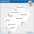
Dosya:Lesotho - Location Map (2013) - LSO - UNOCHA.svg
Asayış

Ebadê verqaytê PNG na dosyay SVG: 250 × 250 piksel. Agoznayışê bini: 240 × 240 piksel | 480 × 480 piksel | 768 × 768 piksel | 1,024 × 1,024 piksel | 2,048 × 2,048 piksel.
Ebato oricinale (Dosyay SVGi, nominal 250 × 250 pikseli, ebadê dosya: 325 KB)
Verêniya dosya
Seba diyayışê viyarteyê dosya ra tarixê ke qısımê tarix/zemani derê inan bıtıkne.
| Tarix/Zeman | Resımo qıckek | Ebadi | Karber | Mışewre | |
|---|---|---|---|---|---|
| nıkayên | 07:18, 9 Şıbat 2024 |  | 250 - 250 (325 KB) | Illchy | Reverted to version as of 07:35, 31 March 2016 (UTC) |
| 04:10, 19 Tışrino Peyên 2022 |  | 250 - 250 (327 KB) | Pengetik-AM | File uploaded using svgtranslate tool (https://svgtranslate.toolforge.org/). Added translation for id. | |
| 07:35, 31 Adare 2016 |  | 250 - 250 (325 KB) | Wereldburger758 | Resized page to drawing. Removal watermark. Validation of image. | |
| 04:38, 21 Nisane 2014 |  | 254 - 254 (350 KB) | UN OCHA maps bot | == {{int:filedesc}} == {{Information |description={{en|1=Locator map of Lesotho.}} |date=2013 |source={{en|1=[http://reliefweb.int/map/lesotho/lesotho-location-map-2013 Lesotho Locator Map (ReliefWeb)]}} |author={{en|1=[[w:en:United Na... |
Gurenayışê dosya
The following pages link to this file:
Gurenayışê dosyaya gılovere
Ena dosya wikiyanê binan de gureniyena.
- arz.wikipedia.org sero guriyayış
- ast.wikipedia.org sero guriyayış
- ca.wikipedia.org sero guriyayış
- ckb.wikipedia.org sero guriyayış
- dag.wikipedia.org sero guriyayış
- de.wikivoyage.org sero guriyayış
- eo.wikinews.org sero guriyayış
- es.wikipedia.org sero guriyayış
- fr.wikivoyage.org sero guriyayış
- ga.wikipedia.org sero guriyayış
- gd.wikipedia.org sero guriyayış
- gl.wikipedia.org sero guriyayış
- gpe.wikipedia.org sero guriyayış
- ha.wikipedia.org sero guriyayış
- hi.wikipedia.org sero guriyayış
- ia.wikipedia.org sero guriyayış
- id.wikipedia.org sero guriyayış
- ig.wikipedia.org sero guriyayış
- incubator.wikimedia.org sero guriyayış
- it.wikipedia.org sero guriyayış
- kab.wikipedia.org sero guriyayış
- ms.wikipedia.org sero guriyayış
- pap.wikipedia.org sero guriyayış
- pl.wikipedia.org sero guriyayış
- sd.wikipedia.org sero guriyayış
- st.wikipedia.org sero guriyayış
- te.wikipedia.org sero guriyayış
- tl.wikipedia.org sero guriyayış
- tt.wikipedia.org sero guriyayış
- vec.wikipedia.org sero guriyayış
- www.wikidata.org sero guriyayış


