
Dosya:Map-of-Ottoman-Empire-in-1900-German.svg

Ebadê verqaytê PNG na dosyay SVG: 800 × 502 piksel. Agoznayışê bini: 320 × 201 piksel | 640 × 401 piksel | 1,024 × 642 piksel | 1,280 × 803 piksel | 2,560 × 1,605 piksel | 2,647 × 1,660 piksel.
Ebato oricinale (Dosyay SVGi, nominal 2,647 × 1,660 pikseli, ebadê dosya: 82 KB)
| Na dosya depoyê Wikimedia Commons de esta u terefê proceyanê binan ra gureniyena. Cêr dê şınasiya dosyay pela mocniyeno. |
| Şınasnayış |
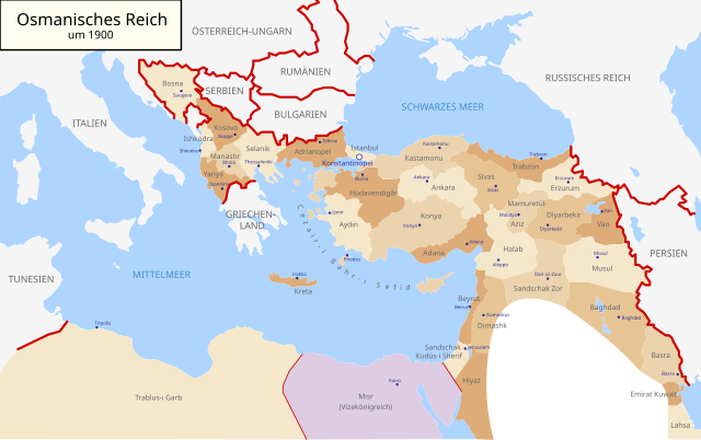
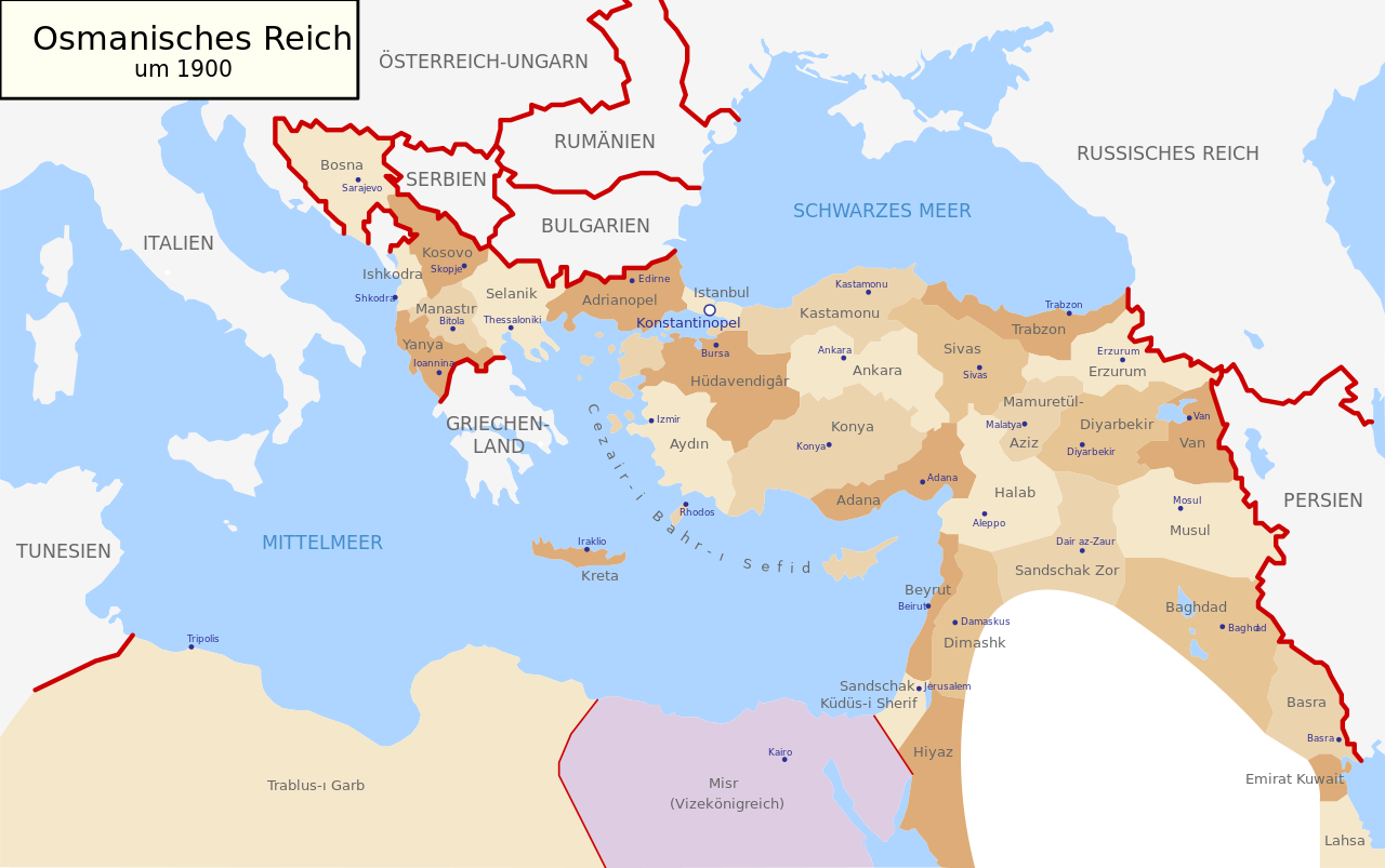
Deutsch: Karte des Osmanischen Reiches um 1900 in Deutsch
English: Map of Ottoman Empire (1900) in German |
| Tarix | (UTC) |
| Çıme | |
| Nuştekar |
|
| Versiyonane binan |
Map-of-Ottoman-Empire-in-1900-German.svg[]
Derivative works of this file: |


.svg)
.jpg)
Ez, ke ena dosya viraste, bine ena lisans ser cap kena:
| Ez, Wêrê ena teliferê, nê kari Malê şarideye ezo heserena. Dınya heme ca dı ravêreno. Tay dewletan dı no kanuniyey heta mıkum nêbone; o haldı: Ez, ena karer qande herhangi yew amaci, be şert, hendı ke legali icab nikeni, şari hemi re ezo mısade dana. |
Qeydê barkerdışê oricinali
This image is a derivative work of the following images:
- File:Map-of-Ottoman-Empire-in-1900-Latvian.svg licensed with PD-self
- 2008-01-30T21:53:09Z Juristiltins 885x557 (105823 Bytes) {{Information |Description=Map of Ottoman Empire (1900) in Latvian |Source=own work |Date=30 January 2008 |Author=Juris Tiltins |Permission=Free use and distribution permitted. |other_versions= }} [[Category:Maps of the Ottom
Uploaded with derivativeFX
Verêniya dosya
Seba diyayışê viyarteyê dosya ra tarixê ke qısımê tarix/zemani derê inan bıtıkne.
| Tarix/Zeman | Resımo qıckek | Ebadi | Karber | Mışewre | |
|---|---|---|---|---|---|
| nıkayên | 09:25, 18 Gulane 2018 | | 2,647 - 1,660 (82 KB) | NordNordWest | corr |
| 16:03, 15 Keşkelun 2010 |  | 2,647 - 1,660 (79 KB) | NordNordWest | c | |
| 16:01, 15 Keşkelun 2010 |  | 2,646 - 1,660 (79 KB) | NordNordWest | c | |
| 16:00, 15 Keşkelun 2010 |  | 2,646 - 1,660 (79 KB) | NordNordWest | c | |
| 18:30, 28 Tebaxe 2010 |  | 2,645 - 1,661 (112 KB) | NordNordWest | bigger | |
| 18:18, 28 Tebaxe 2010 |  | 885 - 557 (96 KB) | NordNordWest | {{Information |Description={{de|Karte des Osmanischen Reiches um 1900 in Deutsch}} {{en|Map of Ottoman Empire (1900) in German}} |Source=*File:Map-of-Ottoman-Empire-in-1900-Latvian.svg |Date=2010-08-28 18:18 (UTC) |Author=*[[:File:Map-of-Ottoman-Emp |
Gurenayışê dosya
There are no pages that link to this file.
Gurenayışê dosyaya gılovere
Ena dosya wikiyanê binan de gureniyena.
- af.wikipedia.org sero guriyayış
- als.wikipedia.org sero guriyayış
- cy.wikipedia.org sero guriyayış
- de.wikipedia.org sero guriyayış
- en.wikipedia.org sero guriyayış
- he.wikipedia.org sero guriyayış
- it.wikipedia.org sero guriyayış
- lv.wikipedia.org sero guriyayış
- no.wikipedia.org sero guriyayış
- pl.wikipedia.org sero guriyayış
- pnb.wikipedia.org sero guriyayış
- ru.wikipedia.org sero guriyayış
- sk.wikipedia.org sero guriyayış
- sr.wikipedia.org sero guriyayış
- sv.wikipedia.org sero guriyayış
- tr.wikipedia.org sero guriyayış
- ur.wikipedia.org sero guriyayış