
Dosya:NewBritainOMC.png
Deha berz agozney cı çıniyo
NewBritainOMC.png (491 × 349 pikselan, ebatê dosya: 10 KB, MIME tipê cı: image/png)
| Na dosya depoyê Wikimedia Commons de esta u terefê proceyanê binan ra gureniyena. Cêr dê şınasiya dosyay pela mocniyeno. |
Xulasa
| Şınasnayış |
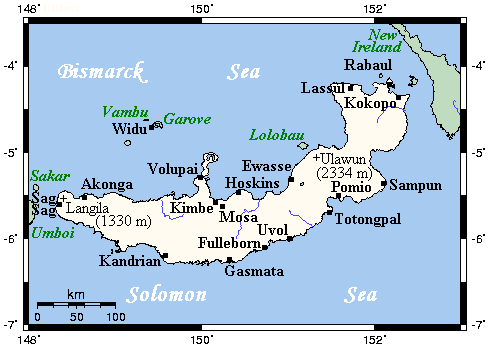
English: A map showing main towns and volcanoes of New Britain, Bismarck Archipelago, Papau New Guinea |
| Çıme | This map's source is here, with the uploader's modifications, and the GMT homepage says that the tools are released under the GNU General Public License |
| Nuştekar | unknown, modified by Kelisi (talk) |
| Destur (Reyna sixulnayise ena dosya) |
GFDL-SELF-WITH-DISCLAIMERS; Released under the GNU Free Documentation License |
Lisans
Kelisi, ke ena dosya viraste, bine ena lisans ser cap kena:
| Ena dosya binê Creative Commons Attribution-Share Alike 3.0 Unported lisans biya. Subject to disclaimers. | ||
| Gırêdayış: Kelisi | ||
| ||
| Na etiketa lsansi, Dosya dı yew letey GFDL Lisans kerdışi newekerdışi bo deye debiyayo de. |

|
Şıma şenê ena dosya kopya kerê, vıla kerê ya zi bıvırnê bınê GNU Free Documentation License, Versiyon 1.2 ya zi versiyonane ke cap biye pê Free Software Foundation; pê nê Invariant Sections, nê Front-Cover Texts u nê Back-Cover Texts. You qısımê kopya bine GNU Free Documentation License estê. Subject to disclaimers. |
Qeydê barkerdışê oricinali
All following user names refer to en.wikipedia.
- 2007-07-21 21:43 Kelisi 491×349×8 (10649 bytes) Sorry, forgot scale.
- 2007-07-21 20:12 Kelisi 491×349×8 (10420 bytes) A map showing New Britain's main towns and volcanoes. This map's source is [http://www.aquarius.ifm-geomar.de/ here], with the uploader's modifications, and the [http://gmt.soest.hawaii.edu/ GMT homepage] says that the tools are released und
Verêniya dosya
Seba diyayışê viyarteyê dosya ra tarixê ke qısımê tarix/zemani derê inan bıtıkne.
| Tarix/Zeman | Resımo qıckek | Ebadi | Karber | Mışewre | |
|---|---|---|---|---|---|
| nıkayên | 14:01, 27 Çele 2008 | | 491 - 349 (10 KB) | File Upload Bot (Magnus Manske) | {{BotMoveToCommons|en.wikipedia}} {{Information |Description={{en|A map showing New Britain's main towns and volcanoes. This map's source is [http://www.aquarius.ifm-geomar.de/ here], with the uploader's modifications, and the [http://gmt.soest.hawaii.ed |
Gurenayışê dosya
The following pages link to this file:
Gurenayışê dosyaya gılovere
Ena dosya wikiyanê binan de gureniyena.
- af.wikipedia.org sero guriyayış
- az.wikipedia.org sero guriyayış
- ba.wikipedia.org sero guriyayış
- bg.wikipedia.org sero guriyayış
- bs.wikipedia.org sero guriyayış
- cy.wikipedia.org sero guriyayış
- da.wikipedia.org sero guriyayış
- en.wikipedia.org sero guriyayış
- eo.wikipedia.org sero guriyayış
- es.wikipedia.org sero guriyayış
- ga.wikipedia.org sero guriyayış
- gl.wikipedia.org sero guriyayış
- he.wikipedia.org sero guriyayış
- hr.wikipedia.org sero guriyayış
- hu.wikipedia.org sero guriyayış
- hy.wikipedia.org sero guriyayış
- it.wikipedia.org sero guriyayış
- ja.wikipedia.org sero guriyayış
- ka.wikipedia.org sero guriyayış
- kk.wikipedia.org sero guriyayış
- lt.wikipedia.org sero guriyayış
- mrj.wikipedia.org sero guriyayış
- nl.wikipedia.org sero guriyayış
- nn.wikipedia.org sero guriyayış
- ro.wikipedia.org sero guriyayış
- ru.wikipedia.org sero guriyayış
- sr.wikipedia.org sero guriyayış
- sw.wikipedia.org sero guriyayış
- ta.wikipedia.org sero guriyayış
- tpi.wikipedia.org sero guriyayış
- tr.wikipedia.org sero guriyayış
- uk.wikipedia.org sero guriyayış
- vi.wikipedia.org sero guriyayış