
Dosya:Poland location map.svg

Ebadê verqaytê PNG na dosyay SVG: 617 × 600 piksel. Agoznayışê bini: 247 × 240 piksel | 494 × 480 piksel | 790 × 768 piksel | 1,053 × 1,024 piksel | 2,107 × 2,048 piksel | 861 × 837 piksel.
Ebato oricinale (Dosyay SVGi, nominal 861 × 837 pikseli, ebadê dosya: 213 KB)
| Na dosya depoyê Wikimedia Commons de esta u terefê proceyanê binan ra gureniyena. Cêr dê şınasiya dosyay pela mocniyeno. |
Xulasa
| Şınasnayış |
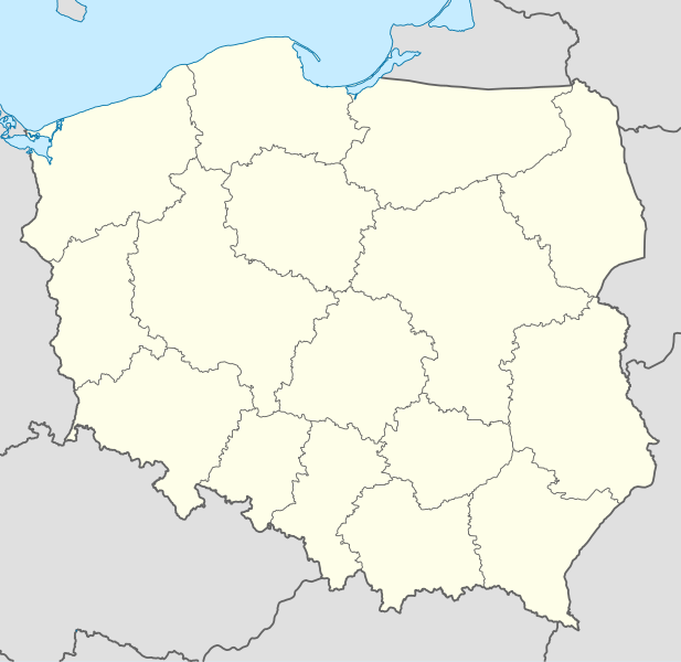
Deutsch: Positionskarte von Polen
Quadratische Plattkarte, N-S-Streckung 160 %. Geographische Begrenzung der Karte:
English: Location map of Poland
Equirectangular projection, N/S stretching 160 %. Geographic limits of the map:
|
||
| Tarix | |||
| Çıme |
Karo şexsi using
|
||
| Nuştekar | NordNordWest | ||
| Versiyonane binan |
|
||
| SVG genesis | This W3C-invalid map was created with Adobe Illustrator.
|


Lisans
Ez, ke ena dosya viraste, bine ena lisansan ser cap kena:

|
Şıma şenê ena dosya kopya kerê, vıla kerê ya zi bıvırnê bınê GNU Free Documentation License, Versiyon 1.2 ya zi versiyonane ke cap biye pê Free Software Foundation; pê nê Invariant Sections, nê Front-Cover Texts u nê Back-Cover Texts. You qısımê kopya bine GNU Free Documentation License estê. |
Ena dosya binê Creative Commons Attribution-Share Alike 3.0 Unported lisans biya.
- Nê weçenegan dê xoseri:
- bare kerdene – qe gure kopya kerdişi, vila kerdişi u şawitişi
- qe reyna mix kerdişi – qe kabul kerdişi gure
- bine enê şarti:
- gıredayış – Lazımo ke şıma icazet bıdê, lisansi rê link, vuriyayış ke biyo belû kerê. Ney şıma usulên ra şenê bıkerê, labelê karkerdış u iştirakê şıma terefê wayirê lisansi ra zey qebulbiyene yew qeyde çıniyo.
- sey yewbini barekerdış – Meqaleyi ke reyna têv dê, tadê ya zi fına inşa bıkerê, iştırakê şıma lazımo ke zey orcinali same or compatible license bın de vıla kerê.
Ti eskena lisanse xo biwecini.
Verêniya dosya
Seba diyayışê viyarteyê dosya ra tarixê ke qısımê tarix/zemani derê inan bıtıkne.
| Tarix/Zeman | Resımo qıckek | Ebadi | Karber | Mışewre | |
|---|---|---|---|---|---|
| nıkayên | 12:34, 2 Tışrino Verên 2012 | | 861 - 837 (213 KB) | Palosirkka | Reverted to version as of 20:23, 23 November 2011 Location maps must remain very accurate |
| 20:37, 1 Tışrino Verên 2012 |  | 861 - 837 (196 KB) | Palosirkka | Scrubbed with http://codedread.com/scour/ | |
| 20:23, 23 Tışrino Peyên 2011 |  | 861 - 837 (213 KB) | NordNordWest | upd | |
| 11:28, 8 Kanun 2008 |  | 862 - 838 (377 KB) | NordNordWest | Reverted to version as of 09:25, 8 July 2008, an often used image shouldn't be changed without discussion | |
| 09:26, 8 Kanun 2008 |  | 862 - 838 (378 KB) | Mareklug | I made the featured background (territory of Poland) pure white for better contrast. | |
| 09:25, 8 Temuze 2008 |  | 862 - 838 (377 KB) | NordNordWest | {{Information |Description= {{de|Positionskarte von Polen}} Quadratische Plattkarte, N-S-Streckung 160 %. Geographische Begrenzung der Karte: * N: 55.2° N * S: 48.7° N * W: 13.8° O * O: 24.5° O {{en|Location map of Poland} |
Gurenayışê dosya
The following pages link to this file:
Gurenayışê dosyaya gılovere
Ena dosya wikiyanê binan de gureniyena.
- ar.wikipedia.org sero guriyayış
- av.wikipedia.org sero guriyayış
- bn.wikipedia.org sero guriyayış
- bs.wikipedia.org sero guriyayış
- ceb.wikipedia.org sero guriyayış
- ckb.wikipedia.org sero guriyayış
- de.wikipedia.org sero guriyayış
- el.wikipedia.org sero guriyayış
- en.wikipedia.org sero guriyayış
- en.wikivoyage.org sero guriyayış
- en.wiktionary.org sero guriyayış
- eo.wikipedia.org sero guriyayış
- eo.wikivoyage.org sero guriyayış
- es.wikipedia.org sero guriyayış
- fa.wikipedia.org sero guriyayış
- fo.wikipedia.org sero guriyayış
- fr.wikipedia.org sero guriyayış
- hr.wikipedia.org sero guriyayış
- hsb.wikipedia.org sero guriyayış
- hu.wikipedia.org sero guriyayış
Yê na dosya gurenayışê gıloveri tayêna bıvêne.