
Dosya:Tabaristan boundary.png
Deha berz agozney cı çıniyo
Tabaristan_boundary.png (659 × 571 pikselan, ebatê dosya: 831 KB, MIME tipê cı: image/png)
| Na dosya depoyê Wikimedia Commons de esta u terefê proceyanê binan ra gureniyena. Cêr dê şınasiya dosyay pela mocniyeno. |

|
This historical map image could be re-created using vector graphics as an SVG file. This has several advantages; see Commons:Media for cleanup for more information. If an SVG form of this image is available, please upload it and afterwards replace this template with
{{vector version available|new image name}}.
It is recommended to name the SVG file “Tabaristan boundary.svg”—then the template Vector version available (or Vva) does not need the new image name parameter. |
Xulasa
| Şınasnayış |
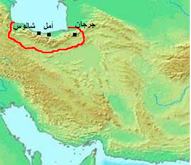
العربية: الحدود التقريبية لإقليم طبرستان القديم، بناءً على هذه الخريطة ووصف ياقوت الحموي في كتابه معجم البلدان للمنطقة.
English: Approximate boundary of Tabaristan region, based upon that map and Mu'jam Al-Buldan of Yaqut al-Hamawi description for the region. |
| Tarix | for the latest version |
| Çıme | modified from Asia 100bc.jpg |
| Nuştekar | Thomas A. Lessman (modified by aad_Dira) |
Lisans
Ena dosya binê Creative Commons Attribution-Share Alike 3.0 Unported lisans biya.
- Nê weçenegan dê xoseri:
- bare kerdene – qe gure kopya kerdişi, vila kerdişi u şawitişi
- qe reyna mix kerdişi – qe kabul kerdişi gure
- bine enê şarti:
- gıredayış – Lazımo ke şıma icazet bıdê, lisansi rê link, vuriyayış ke biyo belû kerê. Ney şıma usulên ra şenê bıkerê, labelê karkerdış u iştirakê şıma terefê wayirê lisansi ra zey qebulbiyene yew qeyde çıniyo.
- sey yewbini barekerdış – Meqaleyi ke reyna têv dê, tadê ya zi fına inşa bıkerê, iştırakê şıma lazımo ke zey orcinali same or compatible license bın de vıla kerê.
Verêniya dosya
Seba diyayışê viyarteyê dosya ra tarixê ke qısımê tarix/zemani derê inan bıtıkne.
| Tarix/Zeman | Resımo qıckek | Ebadi | Karber | Mışewre | |
|---|---|---|---|---|---|
| nıkayên | 21:22, 17 Adare 2011 | | 659 - 571 (831 KB) | عباد ديرانية | تعزيز لون الحدود. |
| 20:39, 17 Adare 2011 |  | 659 - 571 (838 KB) | عباد ديرانية | {{Information |Description ={{ar|1=الحدود التقريبية لإقليم طبرستان القديم، بناءً على [http://www.nooor.com/media/3692/%D8%AE%D8%B1%D9%8A%D8%B7%D8%A9_%D8%B7%D8%A8%D8%B1%D8%B3%D8%AA%D8%A7%D9%86/ هذه الخر� |
Gurenayışê dosya
The following pages link to this file:
Gurenayışê dosyaya gılovere
Ena dosya wikiyanê binan de gureniyena.
- ar.wikipedia.org sero guriyayış