
Dosya:Tennoji-ku in Osaka City.svg

Ebato oricinale (Dosyay SVGi, nominal 403 × 404 pikseli, ebadê dosya: 26 KB)
| Na dosya depoyê Wikimedia Commons de esta u terefê proceyanê binan ra gureniyena. Cêr dê şınasiya dosyay pela mocniyeno. |
Xulasa
| Şınasnayış |
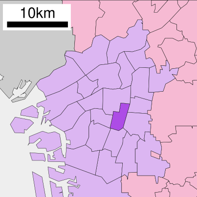
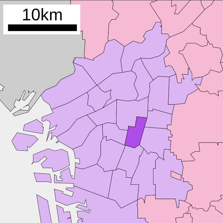
English: Location of Tennoji-ku of Osaka city in Osaka prefecture, Japan
|
||
| Tarix | (UTC) | ||
| Çıme |
|
||
| Nuştekar | Lincun | ||
| Destur (Reyna sixulnayise ena dosya) |
|
Lisans

|
Şıma şenê ena dosya kopya kerê, vıla kerê ya zi bıvırnê bınê GNU Free Documentation License, Versiyon 1.2 ya zi versiyonane ke cap biye pê Free Software Foundation; pê nê Invariant Sections, nê Front-Cover Texts u nê Back-Cover Texts. You qısımê kopya bine GNU Free Documentation License estê. |
- Nê weçenegan dê xoseri:
- bare kerdene – qe gure kopya kerdişi, vila kerdişi u şawitişi
- qe reyna mix kerdişi – qe kabul kerdişi gure
- bine enê şarti:
- gıredayış – Lazımo ke şıma icazet bıdê, lisansi rê link, vuriyayış ke biyo belû kerê. Ney şıma usulên ra şenê bıkerê, labelê karkerdış u iştirakê şıma terefê wayirê lisansi ra zey qebulbiyene yew qeyde çıniyo.
- sey yewbini barekerdış – Meqaleyi ke reyna têv dê, tadê ya zi fına inşa bıkerê, iştırakê şıma lazımo ke zey orcinali same or compatible license bın de vıla kerê.
Qeydê barkerdışê oricinali
| This file was moved from Japanese Wikipedia.
See below for original file information. | ||||||||||||||||||||||||||||
| ||||||||||||||||||||||||||||
|
| ||||||||||||||||||||||||||||
Verêniya dosya
Seba diyayışê viyarteyê dosya ra tarixê ke qısımê tarix/zemani derê inan bıtıkne.
| Tarix/Zeman | Resımo qıckek | Ebadi | Karber | Mışewre | |
|---|---|---|---|---|---|
| nıkayên | 09:12, 22 Tışrino Verên 2020 | | 403 - 404 (26 KB) | AichiWikiFixer | Updated as File:Map_of_Osaka_Prefecture_Ja.svg |
| 11:40, 10 Tışrino Verên 2009 |  | 400 - 472 (11 KB) | Monaneko | {{Information |Description={{en|1=Location of Tennoji-ku in Osaka City}} {{ja|1=大阪市天王寺区の位置}} |Source=ja:File:行政区位置図 27109.svg |Author=ja:User:Lincun |Date=2007-12-07 14:29 (UTC) |Permission= |other_versions= }} [ | |
| 14:29, 7 Kanun 2007 |  | 400 - 472 (11 KB) | Lincun | {{行政区位置図画像情報|大阪府|大阪市|天王寺区}} |
Gurenayışê dosya
The following pages link to this file:
Gurenayışê dosyaya gılovere
Ena dosya wikiyanê binan de gureniyena.
- ar.wikipedia.org sero guriyayış
- ca.wikipedia.org sero guriyayış
- en.wikipedia.org sero guriyayış
- eo.wikipedia.org sero guriyayış
- es.wikipedia.org sero guriyayış
- fa.wikipedia.org sero guriyayış
- fi.wikipedia.org sero guriyayış
- fr.wikipedia.org sero guriyayış
- id.wikipedia.org sero guriyayış
- ja.wikipedia.org sero guriyayış
- ko.wikipedia.org sero guriyayış
- la.wikipedia.org sero guriyayış
- sco.wikipedia.org sero guriyayış
- th.wikipedia.org sero guriyayış
- tr.wikipedia.org sero guriyayış
- vi.wikipedia.org sero guriyayış
- www.wikidata.org sero guriyayış
- zh.wikipedia.org sero guriyayış