
Dosya:Whale pier elements over Meuse.jpg

Vervênayışê ebadê: 800 × 600 piksel. Agoznayışê bini: 320 × 240 piksel | 640 × 480 piksel | 1,024 × 768 piksel | 1,280 × 960 piksel | 2,272 × 1,704 piksel.
Ebato oricinale (2,272 × 1,704 pikselan, ebatê dosya: 1.32 MB, MIME tipê cı: image/jpeg)
| Na dosya depoyê Wikimedia Commons de esta u terefê proceyanê binan ra gureniyena. Cêr dê şınasiya dosyay pela mocniyeno. |
Xulasa
| Şınasnayış |
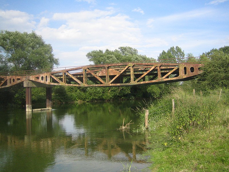
English: Bridge over river Meuse formed with assembled 'Whale' pier elements. This bridge is located in Vacherauville (Meuse). These piers were the floating roadways that connected the Spud pier heads to the land in a Mulberry harbour, a type of temporary harbour developed in World War II to offload cargo on the beaches during the Allied invasion of Normandy.
Français : Pont sur la Meuse formé de pontons 'Whale'. Ce pont est localisé à Vacherauville (Meuse). Ces pontons reliaient les têtes Spud dans un port Mulberry. Un port Mulberry était un port artificiel construit sur la côte normande pendant la Seconde Guerre mondiale pour permettre l'approvisionnement des armées alliées dans les jours qui suivirent le débarquement de Normandie. |
| Tarix | |
| Çıme | Karo şexsi |
| Nuştekar | Foxandpotatoes |
Lisans
Ez, ke ena dosya viraste, bine ena lisansan ser cap kena:

|
Şıma şenê ena dosya kopya kerê, vıla kerê ya zi bıvırnê bınê GNU Free Documentation License, Versiyon 1.2 ya zi versiyonane ke cap biye pê Free Software Foundation; pê nê Invariant Sections, nê Front-Cover Texts u nê Back-Cover Texts. You qısımê kopya bine GNU Free Documentation License estê. |
Ena dosya binê lisansê Creative Commons Attribution-Share Alike 3.0 Unported, 2.5 Generic, 2.0 Generic and 1.0 Generic lisans biya.
- Nê weçenegan dê xoseri:
- bare kerdene – qe gure kopya kerdişi, vila kerdişi u şawitişi
- qe reyna mix kerdişi – qe kabul kerdişi gure
- bine enê şarti:
- gıredayış – Lazımo ke şıma icazet bıdê, lisansi rê link, vuriyayış ke biyo belû kerê. Ney şıma usulên ra şenê bıkerê, labelê karkerdış u iştirakê şıma terefê wayirê lisansi ra zey qebulbiyene yew qeyde çıniyo.
- sey yewbini barekerdış – Meqaleyi ke reyna têv dê, tadê ya zi fına inşa bıkerê, iştırakê şıma lazımo ke zey orcinali same or compatible license bın de vıla kerê.
Ti eskena lisanse xo biwecini.
| Camera location | | View this and other nearby images on: OpenStreetMap |
|---|
Verêniya dosya
Seba diyayışê viyarteyê dosya ra tarixê ke qısımê tarix/zemani derê inan bıtıkne.
| Tarix/Zeman | Resımo qıckek | Ebadi | Karber | Mışewre | |
|---|---|---|---|---|---|
| nıkayên | 19:35, 25 Hezirane 2008 | | 2,272 - 1,704 (1.32 MB) | Foxandpotatoes | {{Information |Description={{en|1=Bridge over river Meuse formed with assembled 'Whale' pier elements. This bridge is located in Vacherauville (Meuse). These piers were the floating roadways that connected the Spud pier heads to the land in a Mulberry har |
Gurenayışê dosya
The following pages link to this file:
Gurenayışê dosyaya gılovere
Ena dosya wikiyanê binan de gureniyena.
- ast.wikipedia.org sero guriyayış
- ca.wikipedia.org sero guriyayış
- ce.wikipedia.org sero guriyayış
- es.wikipedia.org sero guriyayış
- eu.wikipedia.org sero guriyayış
- fr.wikipedia.org sero guriyayış
- hu.wikipedia.org sero guriyayış
- it.wikipedia.org sero guriyayış
- ku.wikipedia.org sero guriyayış
- la.wikipedia.org sero guriyayış
- ms.wikipedia.org sero guriyayış
- nl.wikipedia.org sero guriyayış
- pl.wikipedia.org sero guriyayış
- pt.wikipedia.org sero guriyayış
- ro.wikipedia.org sero guriyayış
- sk.wikipedia.org sero guriyayış
- sv.wikipedia.org sero guriyayış
- tt.wikipedia.org sero guriyayış
- uk.wikipedia.org sero guriyayış
- uz.wikipedia.org sero guriyayış
- vec.wikipedia.org sero guriyayış
- www.wikidata.org sero guriyayış
- zh-min-nan.wikipedia.org sero guriyayış
- zh.wikipedia.org sero guriyayış