
Dosya:Pisces constellation map.png

Ebato oricinale (2,559 × 2,559 pikselan, ebatê dosya: 243 KB, MIME tipê cı: image/png)
| Na dosya depoyê Wikimedia Commons de esta u terefê proceyanê binan ra gureniyena. Cêr dê şınasiya dosyay pela mocniyeno. |
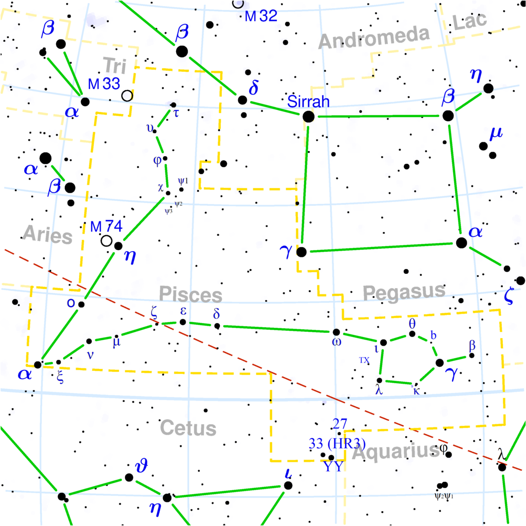
Copyright © 2003 Torsten Bronger.
It was created by Torsten Bronger using the program PP3 on 2003/08/18. At PP3's homepage, you also get the input scripts necessary for re-compiling the map.
The yellow dashed lines are constellation boundaries, the red dashed line is the ecliptic, and the shades of blue show Milky Way areas of different brightness. The map contains all Messier objects, except for colliding ones. The underlying database contains all stars brighter than 6.5. All coordinates refer to equinox 2000.0.
The map is calculated with the equidistant azimuthal projection (the zenith being in the center of the image). The north pole is to the top. The (horizontal) lines of equal declination are drawn for 0°, ±10°, ±20° etc. The lines of equal right ascension are drawn for all 24 hours. Towards the rim there is a very slight magnification (and distortion).

|
File:Pisces constellation map.svg is a vector version of this file. It should be used in place of this PNG file when not inferior.
File:Pisces constellation map.png → File:Pisces constellation map.svg
For more information, see Help:SVG. |
 |

|
Şıma şenê ena dosya kopya kerê, vıla kerê ya zi bıvırnê bınê GNU Free Documentation License, Versiyon 1.2 ya zi versiyonane ke cap biye pê Free Software Foundation; pê nê Invariant Sections, nê Front-Cover Texts u nê Back-Cover Texts. You qısımê kopya bine GNU Free Documentation License estê. |
| Ena dosya binê Creative Commons Attribution-Share Alike 3.0 Unported lisans biya. | ||
| ||
| Na etiketa lsansi, Dosya dı yew letey GFDL Lisans kerdışi newekerdışi bo deye debiyayo de. |
derivative works
Derivative works of this file: Pisces constellation map.svg
Verêniya dosya
Seba diyayışê viyarteyê dosya ra tarixê ke qısımê tarix/zemani derê inan bıtıkne.
| Tarix/Zeman | Resımo qıckek | Ebadi | Karber | Mışewre | |
|---|---|---|---|---|---|
| nıkayên | 20:32, 18 Tışrino Peyên 2020 | | 2,559 - 2,559 (243 KB) | Adam37 | Added stars from the various pages of wikipedia, hours work to do so, kindly do not delete. |
| 22:28, 21 Hezirane 2015 |  | 2,559 - 2,559 (100 KB) | Cmdrjameson | Compressed with pngout. Reduced by 76kB (43% decrease). | |
| 18:23, 12 Kanun 2004 |  | 2,559 - 2,559 (176 KB) | Alfio | Pisces constellation map |
Gurenayışê dosya
There are no pages that link to this file.
Gurenayışê dosyaya gılovere
Ena dosya wikiyanê binan de gureniyena.
- af.wikipedia.org sero guriyayış
- ar.wikipedia.org sero guriyayış
- ast.wikipedia.org sero guriyayış
- be.wikipedia.org sero guriyayış
- bg.wikipedia.org sero guriyayış
- bn.wikipedia.org sero guriyayış
- ca.wikipedia.org sero guriyayış
- co.wikipedia.org sero guriyayış
- da.wikipedia.org sero guriyayış
- de.wikipedia.org sero guriyayış
- de.wiktionary.org sero guriyayış
- el.wikipedia.org sero guriyayış
- el.wiktionary.org sero guriyayış
- en.wikipedia.org sero guriyayış
- en.wiktionary.org sero guriyayış
- es.wikipedia.org sero guriyayış
- fa.wikipedia.org sero guriyayış
- fi.wikipedia.org sero guriyayış
- frr.wikipedia.org sero guriyayış
- ga.wikipedia.org sero guriyayış
- gl.wikipedia.org sero guriyayış
- he.wiktionary.org sero guriyayış
- hi.wikipedia.org sero guriyayış
- hr.wikipedia.org sero guriyayış
- hu.wikipedia.org sero guriyayış
- hu.wiktionary.org sero guriyayış
- id.wikipedia.org sero guriyayış
- it.wikipedia.org sero guriyayış
- it.wiktionary.org sero guriyayış
Yê na dosya gurenayışê gıloveri tayêna bıvêne.